Armistead Gardens | |
|---|---|
neighborhood statistical area | |
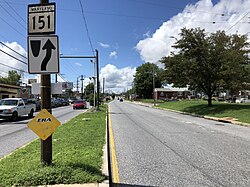
 View north along 4800 block of Erdman Avenue with houses in Armistead Gardens, Baltimore to the right | |
| Coordinates: 39°18′8″N 76°32′59″W / 39.30222°N 76.54972°W | |
| Country | United States |
| State | Maryland |
| City | Baltimore |
| Area | |
| • Total | 0.529 sq mi (1.37 km2) |
| • Land | 0.529 sq mi (1.37 km2) |
| Population (2009)[1] | |
| • Total | 2,864 |
| • Density | 5,400/sq mi (2,100/km2) |
| Time zone | UTC-5 (Eastern) |
| • Summer (DST) | UTC-4 (EDT) |
| Area code | 410, 443, and 667 |
Armistead Gardens is a neighborhood in the Northeast District of Baltimore. It is located north of Pulaski Highway and east of Erdman Avenue, between Herring Run Park (northeast) and the East District neighborhood of Orangeville (southwest).[2][3]
Armistead Gardens is home to four churches, Armistead Gardens Elementary School, and the Bohemian National Cemetery. The nearest major highways are Pulaski Highway (U.S. Route 40) and Erdman Avenue.
- ^ a b "Armistead Gardens neighborhood in Baltimore". City-data.com. Retrieved June 30, 2011.
- ^ "Northeast District Maps". Baltimore City Neighborhoods Portal. City of Baltimore. Archived from the original on 1 July 2011. Retrieved June 30, 2011.
- ^ "Discover Your Neighborhood". Live Baltimore. Retrieved June 30, 2011.
