Arna Municipality
Arna kommune | |
|---|---|
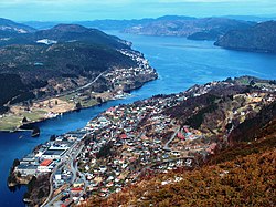
 View from Ådnanipa towards Indre Arna | |
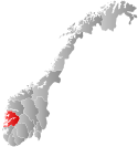
 Hordaland within Norway | |
 Arna within Hordaland | |
| Coordinates: 60°25′03″N 05°28′15″E / 60.41750°N 5.47083°E | |
| Country | Norway |
| County | Hordaland |
| District | Midhordland |
| Established | 1 Jan 1964 |
| • Preceded by | Haus Municipality |
| Disestablished | 1 Jan 1972 |
| • Succeeded by | Bergen Municipality |
| Administrative centre | Indre Arna |
| Government | |
| • Mayor (1967-1971) | Arne Ekeland (Ap) |
| Area (upon dissolution)[1] | |
• Total | 102.44 km2 (39.55 sq mi) |
| Population (1971) | |
• Total | 11,476 |
| • Density | 110/km2 (290/sq mi) |
| Time zone | UTC+01:00 (CET) |
| • Summer (DST) | UTC+02:00 (CEST) |
| ISO 3166 code | NO-1250[2] |
Arna is a former municipality in the old Hordaland county, Norway. The municipality existed from 1964 until 1972. It encompassed the northeastern part of the Bergen Peninsula, along the Sørfjorden, bordering the city of Bergen across the mountains to the west. The administrative centre of the municipality was the village of Indre Arna. The municipality stretched from the village of Ytre Arna to Trengereid along the coast and then inland about 8 kilometres (5.0 mi) to the Espeland area.[1] Today, the area of the former municipality makes up the borough of Arna in the city of Bergen.
- ^ a b Store norske leksikon. "Arna" (in Norwegian). Retrieved 12 September 2014.
- ^ Bolstad, Erik; Thorsnæs, Geir, eds. (26 January 2023). "Kommunenummer". Store norske leksikon (in Norwegian). Kunnskapsforlaget.