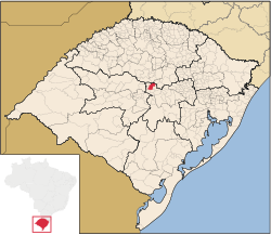
Arroio do Tigre | |
|---|---|
Municipality | |
| Nickname: Celeiro do centro-serra | |
 | |
| Coordinates: 29°19′58″S 53°05′34″W / 29.33278°S 53.09278°W | |
| Country | Brazil |
| State | Rio Grande do Sul |
| Mesoregion | Centro Oriental Rio-grandense[1] |
| Microregion | Santa Cruz do Sul[1] |
| Founded | November 6, 1963 |
| Government | |
| • Mayor | Gilberto Rathke |
| Area | |
| • Total | 318.524 km2 (122.983 sq mi) |
| Elevation | 409 m (1,342 ft) |
| Population (2020 [2]) | |
| • Total | 13,413 |
| • Density | 42/km2 (110/sq mi) |
| Time zone | UTC−3 (BRT) |
| Area code | +55 51 |
| HDI | 0.764[3] |
| GDP | R$ 125,575,000[4] |
| GDP per capita | R$10,093.00 |
| Website | arroiodotigre.rs.gov.br |
Arroio do Tigre is a municipality in the state of Rio Grande do Sul, Brazil.
The municipality is partly flooded by the reservoir of the Dona Francisca Hydroelectric Plant on the upper Jacuí River.[5]
- ^ a b Cite error: The named reference
IBGE_DTB_2008was invoked but never defined (see the help page). - ^ IBGE 2020
- ^ Cite error: The named reference
PNUD_IDH_2000was invoked but never defined (see the help page). - ^ Cite error: The named reference
IBGE_PIB_2005was invoked but never defined (see the help page). - ^ Dona Francisca (in Portuguese), OSAB: Observatório Sócio-Ambiental da Baragens, archived from the original on 2019-05-23, retrieved 2017-01-20

