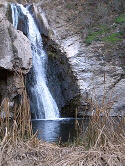
| Arroyo Conejo | |
|---|---|
 Paradise Falls | |
 | |
| Location | |
| Country | United States |
| County | Ventura |
| Physical characteristics | |
| Mouth | |
• location | Discharges to the Pacific by Mugu Lagoon |
| Basin features | |
| River system | Calleguas Creek |
Arroyo Conejo (Spanish for “Rabbit Creek”) carries part of the longest creek in the Conejo Valley[1] which sprawls past the cities of Thousand Oaks and Camarillo, and the communities of Newbury Park, Casa Conejo and Santa Rosa Valley. Arroyo Conejo is the primary drainage for the City of Thousand Oaks.[2] Its watershed covers 57 square miles (150 km2) of which 43 square miles (110 km2) are in the Conejo Valley and 14 square miles (36 km2) in the Santa Rosa Valley.[3]
Historically, it was a seasonal-running creek but urban runoff from irrigation currently makes it perennial. Its north fork carved Wildwood Canyon out of bedrock over several millennia. The south fork originates in the Conejo Hills above Newbury Park. It also follows Thousand Oaks Boulevard, where it runs directly along and below the boulevard. In certain areas, the creek runs through concrete culverts and runs underneath the street. Past Newbury Park's Hill Canyon, the creek meets with Arroyo Santa Rosa in Santa Rosa Valley as it runs through the Pleasant Valley basin on its way across the Oxnard Plain to its estuary at Mugu Lagoon. Due to limited access, suggestions have been made to make its banks into public amenities similar to that of San Antonio River Walk, or, developing a public use trail following the creek, similar to the bike path of Arroyo Simi in Simi Valley, California. It is part of the Calleguas Creek watershed, which drains an area of 343 sq. mi. in southern Ventura County.[4]
Within Wildwood Regional Park, its gorge and its 40-foot (12 m) cascade, Paradise Falls, are among the park’s most visited attractions.[5][6]
- ^ http://www.camrosa.com/documents/GMP%20092013_final.pdf Archived 2016-03-03 at the Wayback Machine (Page 30)
- ^ http://www.camrosa.com/documents/GMP%20092013_final.pdf Archived 2016-03-03 at the Wayback Machine (Page 30)
- ^ Brooks, Norman H. (1982). Storms, Floods, and Debris Flows in Southern California and Arizona 1978 and 1980: Overview and Summary of a Symposium, September 17–18, 1980. National Academies. Pages 155–156.
- ^ "Conejo's inconspicuous creek". May 16, 2018.
- ^ Schad, Jerry (2013). 101 Hikes in Southern California: Exploring Mountains, Seashore, and Desert. Wilderness Press. Page 18. ISBN 9780899977164.
- ^ Schad, Jerry (2011). Top Trails: Los Angeles: Must-Do Hikes for Everyone. Wilderness Press. Page 112. ISBN 9780899976273.