| Arroyo Seco | |
|---|---|
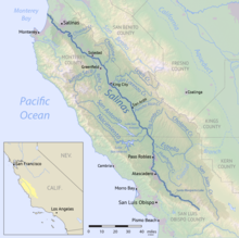
 Map of the Salinas River basin including the Arroyo Seco | |
| Location | |
| Country | United States |
| State | California |
| Physical characteristics | |
| Source | near Junipero Serra Peak |
| • location | Ventana Wilderness, California Coast Ranges |
| • coordinates | 36°07′52″N 121°26′57″W / 36.13111°N 121.44917°W[1] |
| • elevation | 5,480 ft (1,670 m) |
| Mouth | Salinas River |
• location | Greenfield, Monterey County |
• coordinates | 36°24′49″N 121°20′33″W / 36.41361°N 121.34250°W[1] |
• elevation | 164 ft (50 m) |
| Length | 40 mi (64 km) |
| Basin size | 275 sq mi (710 km2) |
| Discharge | |
| • location | near Vaqueros Creek, 10 miles (16 km) from the mouth[2] |
| • average | 168 cu ft/s (4.8 m3/s)[2] |
| • minimum | 0 cu ft/s (0 m3/s) |
| • maximum | 28,300 cu ft/s (800 m3/s) |
The Arroyo Seco[3] ("dry stream") is a major tributary of the Salinas River in central California. About 40 miles (64 km) long, it drains a rugged area of the Coast Ranges east of Big Sur before flowing through the agricultural Salinas Valley.
- ^ a b "Arroyo Seco". Geographic Names Information System. United States Geological Survey, United States Department of the Interior. 1981-01-19. Retrieved 2011-04-23.
- ^ a b "USGS Gage #11152000 on the Arroyo Seco near Soledad, CA" (PDF). National Water Information System. U.S. Geological Survey. 2009. Retrieved 2011-04-22.
- ^ U.S. Geological Survey Geographic Names Information System: Arroyo Seco