Arroyo barrio-pueblo
Pueblo de Arroyo | |
|---|---|
Municipality Seat[1] | |
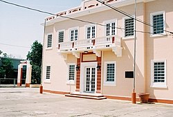
 Town hall in Arroyo | |
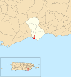
 Location of Arroyo barrio-pueblo within the municipality of Arroyo shown in red | |
| Coordinates: 17°57′47″N 66°03′46″W / 17.962984°N 66.062727°W[2] | |
| Commonwealth | |
| Municipality | |
| Area | |
| • Total | 0.38 sq mi (1.0 km2) |
| • Land | 0.21 sq mi (0.5 km2) |
| • Water | 0.17 sq mi (0.4 km2) |
| Elevation | 10 ft (3 m) |
| Population (2010) | |
| • Total | 1,206 |
| • Density | 3,281/sq mi (1,267/km2) |
| Source: 2010 Census | |
| Time zone | UTC−4 (AST) |
Preview warning: Page using Template:Infobox designation list with unknown parameter "designated_other1_date" Preview warning: Page using Template:Infobox designation list with unknown parameter "designated_other1_color" Preview warning: Page using Template:Infobox designation list with unknown parameter "designated_other1_name" | |
Arroyo barrio-pueblo is a barrio and the administrative center (seat) of Arroyo, a municipality of Puerto Rico. Its population in 2010 was 1,206.[4][5][1]
As was customary in Spain, in Puerto Rico, the municipality has a barrio called pueblo which contains a central plaza, the municipal buildings (city hall), and a Catholic church. Fiestas patronales (patron saint festivals) are held in the central plaza every year.[6][7] The downtown area (pueblo) of Arroyo was added to the Puerto Rico Register of Historic Sites and Zones in 1997.[8]
- ^ a b Puerto Rico: 2010 Population and Housing Unit Counts.pdf (PDF). U.S. Dept. of Commerce, Economics and Statistics Administration, U.S. Census Bureau. 2010.
- ^ a b "US Gazetteer 2019". US Census. US Government.
- ^ U.S. Geological Survey Geographic Names Information System: Arroyo barrio-pueblo
- ^ Picó, Rafael; Buitrago de Santiago, Zayda; Berrios, Hector H. Nueva geografía de Puerto Rico: física, económica, y social, por Rafael Picó. Con la colaboración de Zayda Buitrago de Santiago y Héctor H. Berrios. San Juan Editorial Universitaria, Universidad de Puerto Rico,1969.
- ^ Gwillim Law (20 May 2015). Administrative Subdivisions of Countries: A Comprehensive World Reference, 1900 through 1998. McFarland. p. 300. ISBN 978-1-4766-0447-3. Retrieved 25 December 2018.
- ^ Cite error: The named reference
Santullanowas invoked but never defined (see the help page). - ^ Pariser, Harry S. (2003). Explore Puerto Rico, Fifth Edition. San Francisco: Manatee Press. pp. 52–55. Retrieved 10 February 2019.
- ^ GOBIERNO DE PUERTO RICO, JUNTA DE PLANIFICACIÓN DE PUERTO RICO (December 7, 2022). "REGISTRO DE PROPIEDADES DESIGNADAS POR LA JUNTA DE PLANIFICACIÓN DE PUERTO RICO" (PDF). jp.pr.gov.
