This article needs additional citations for verification. (April 2024) |
Artashat
Արտաշատ | |
|---|---|
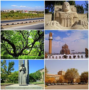
 From top left: View of Artashat • Statue of King Artaxias I Apricot farms • Surp Hovhannes Church World War II memorial • Downtown Artashat | |
| Coordinates: 39°57′14″N 44°33′02″E / 39.95389°N 44.55056°E | |
| Country | Armenia |
| Province | Ararat |
| Municipality | Artashat |
| First settled | 1828–29 |
| Received urban-type settlement status | 1946 |
| Received city status | 1962 |
| Area | |
• Total | 18.3 km2 (7.1 sq mi) |
| Elevation | 830 m (2,720 ft) |
| Population (2022 census)[1] | |
• Total | 19,020 |
| • Density | 1,000/km2 (2,700/sq mi) |
| Time zone | UTC+4 (AMT) |
| ZIP | 0701-0706 |
| Area code | +374 (235) |
| Vehicle registration | 25 |
| Website | Municipality official website |
Artashat (Armenian: Արտաշատ [ɑɾtɑˈʃɑt]) is a town and administrative center of the Artashat Municipality and the Ararat Province of Armenia. It is located on the Azat River in the Ararat Plain, 30 km southeast of Yerevan.
Artashat was originally a village called Ghamarlu, established by Armenian migrants from Iran in 1828–29. It grew into a large village by the late 19th and early 20th centuries. In 1945, it was renamed after the ancient city of Artashat (Artaxata), the ruins of which are located 8 kilometres (5.0 mi) southeast of the city. It received the status of an urban-type settlement in 1946 and that of a city in 1962, growing into an important industrial center in subsequent years.
Artashat is located on the Yerevan-Goris-Stepanakert highway and the currently inoperative Yerevan-Nakhchivan-Baku and Nakhchivan-Tabriz railway. As of the 2022 census, the town had a population of 19,020.[1]
- ^ a b "The Main Results of RA Census 2022". Statistical Committee of the Republic of Armenia. Retrieved 24 February 2024.


