Aysaqiita | |
|---|---|
Town | |
| Asaita | |
 | |
| Motto: Aysaqiiti Magaalah Xiinisso | |
| Coordinates: 11°34′N 41°26′E / 11.567°N 41.433°E | |
| Country | |
| Region | Afar Region |
| Zone | Awsi Rasu |
| Named for | Aysa'eeta meaning foundation or meaning "just leave" or Qeysa qiyte meaning "Eysa holler" |
| Government | |
| • Type | City administration |
| • Mayor | Mohammed Ahmed |
| Elevation | 300 m (1,000 ft) |
| Population (2005) | |
• Total | 22,718 (est) |
| Climate | BWh |
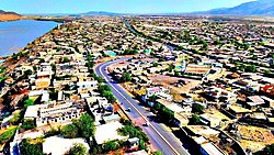
Asaita (Amharic: አሳይታ, Asayəta; Afar: Aysaqiita), known historically as Aussa (Awsa), is a town in northeastern Ethiopia, and until 2007 served as the capital of the Afar Region of Ethiopia. Located in the Afambo woreda, part of the region's Awsi Rasu zone, the town has a latitude and longitude of 11°34′N 41°26′E / 11.567°N 41.433°E and an elevation of 300 metres (980 ft).
Aussa was known by its full known name Aussa Gurêle[1] which was founded upon a rock bound by the rivers Awash, Raheita and Assab.[2] According to Huntingford's opinion the term Gurêle represented the name of a hill 90 miles north-west of Lake Abbe.[3]
Asaita was briefly the capital of the Adal Sultanate[4] and Imamate of Aussa as well as seat of the Aussa Sultanate, the chief Afar monarchy, but is 50 kilometres (31 mi) south by unpaved road from Awash–Asseb highway. A telephone line from Kombolcha to Asaita was in operation in 1964.[5] The town of Semera, a planned settlement situated squarely on this highway, at some point before 2007 became the new capital of the region.
To the southeast of Asaita, located at the southern edge of the Danakil Desert, are a group of twenty salt lakes which cover the territory to the border with neighboring Djibouti. These lakes include Lake Gummare, known for its flamingos, and Lake Abbe, the final destination of the Awash River.
Based on figures from the Central Statistical Agency in 2005, the town has an estimated total population of 22,718, of whom 12,722 were males and 9,996 were females.[6] According to the 1994 national census, the town had a population of 15,475.
- ^ Paulitschke, Philipp Viktor; Hardegger, Dominik Kammel von (1888). Harar: Forschungsreise nach den Somâl und Gallaländern, Ost-Afrikas (in German). F. A. Brockhaus. p. 59.
- ^ Bruce, James (1804). Travels to Discover the Source of the Nile, in the Years 1768, 1769, 1770, 1771, 1772, & 1773. Abyssinia. p. 365.
- ^ Pankhurst, Richard (1997). The Ethiopian Borderlands: Essays in Regional History from Ancient Times to the End of the 18th Century. The Red Sea Press. p. 381. ISBN 978-0-932415-19-6.
- ^ Shinn, David (11 April 2013). Historical Dictionary of Ethiopia. Scarecrow Press. p. 21. ISBN 9780810874572. Retrieved 19 January 2016.
- ^ "Local History in Ethiopia" Archived 2007-09-27 at the Wayback Machine (pdf) The Nordic Africa Institute website (accessed 21 November 2007)
- ^ CSA 2005 National Statistics Archived November 23, 2006, at the Wayback Machine, Table B.3


