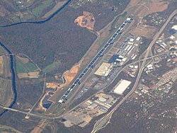
Asheville Regional Airport | |||||||||||
|---|---|---|---|---|---|---|---|---|---|---|---|
 | |||||||||||
 | |||||||||||
| Summary | |||||||||||
| Airport type | Public | ||||||||||
| Owner | City of Asheville | ||||||||||
| Operator | Asheville Regional Airport Authority | ||||||||||
| Serves | Asheville, North Carolina | ||||||||||
| Location | Asheville, North Carolina[1] | ||||||||||
| Opened | 1961 | ||||||||||
| Operating base for | Allegiant Air[2] | ||||||||||
| Elevation AMSL | 2,164 ft / 660 m | ||||||||||
| Coordinates | 35°26′10″N 082°32′30″W / 35.43611°N 82.54167°W | ||||||||||
| Website | flyavl | ||||||||||
| Maps | |||||||||||
 FAA airport diagram | |||||||||||
 | |||||||||||
| Runways | |||||||||||
| |||||||||||
| Statistics | |||||||||||
| |||||||||||
Asheville Regional Airport (IATA: AVL, ICAO: KAVL, FAA LID: AVL) is a Class C airport near Interstate 26 and the town of Fletcher, North Carolina, 9 miles (14 km) south of downtown Asheville. It is owned by the Greater Asheville Regional Airport Authority.[3] The Federal Aviation Administration (FAA) National Plan of Integrated Airport Systems for 2019–2023 categorized it as a small-hub primary commercial service facility.[6] In 2023 it served an all-time record number of passengers for the airport, 2,246,411, an increase of 22.2% over 2022.[7]
The airport opened initially with a 6500-foot runway in 1961, replacing the former airport at 35°26′20″N 82°28′52″W / 35.439°N 82.481°W.
- ^ "HOUSE BILL 1283" (PDF). North Carolina General Assembly. June 18, 1959. Retrieved June 12, 2021.
- ^ "Asheville Takes Off to Fun and Amusement" (Press release). Asheville, NC: Allegiant Travel Company. Acquire Media. September 13, 2011. Retrieved August 15, 2021.
- ^ a b FAA Airport Form 5010 for AVL PDF, effective July 13, 2023.
- ^ "RITA BTS Transtats - AVL". transtats.bts.gov. March 2020. Retrieved June 13, 2020.
- ^ "Asheville Airport has record year for passengers in 2023". flyavl.com. Retrieved February 5, 2024.
- ^ "NPIAS Report 2019-2023 Appendix A" (PDF). Federal Aviation Administration. October 3, 2018. p. 75. Archived (PDF) from the original on October 12, 2018. Retrieved June 14, 2020.
- ^ "Asheville Airport Sets All-Time Record Serving 2,246,411 Passengers in 2023". flyavl.com. Retrieved February 5, 2024.