| Ashmore | |
|---|---|
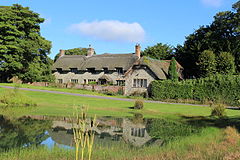
 Ashmore village pond | |
Location within Dorset | |
| Population | 188 [1] |
| OS grid reference | ST912178 |
| • London | 116 mi (187 km) |
| Civil parish |
|
| District | |
| Shire county | |
| Region | |
| Country | England |
| Sovereign state | United Kingdom |
| Post town | Salisbury |
| Postcode district | SP5 |
| Dialling code | 01725 |
| Police | Dorset |
| Fire | Dorset and Wiltshire |
| Ambulance | South Western |
| UK Parliament | |

Ashmore is a village and civil parish in the North Dorset district of Dorset, England, 20 miles (32 kilometres) southwest of Salisbury.
The village is centred on a circular pond and has a church and several stone cottages and farms, many with thatched roofs. It is the highest village in the county with the 220-metre (720-foot) contour passing close to the village church (although the north side of the town of Shaftesbury, Dorset, is slightly higher at 232 m or 761 ft).[2]
The pond or "mere" gave the village its original name of "Ash-mere".[3]
In the 2011 census the parish had a population of 188.[1]
- ^ a b "Area: Ashmore (Parish), Key Figures for 2011 Census: Key Statistics". Neighbourhood Statistics. Office for National Statistics. Archived from the original on 11 October 2016. Retrieved 20 June 2014.
- ^ "Street map". streetmap.co.uk. Retrieved 26 March 2023.
- ^ North Dorset District Council,North Dorset Official District Guide, Home Publishing Co. Ltd.,c.1983. p30
