Ashtabula, Ohio | |
|---|---|
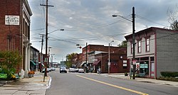
 Bridge Street in Ashtabula Harbor | |
| Nickname(s): | |
 Interactive map of Ashtabula | |
| Coordinates: 41°52′28″N 80°47′45″W / 41.87444°N 80.79583°W | |
| Country | United States |
| State | Ohio |
| County | Ashtabula |
| Government | |
| • Type | Council-manager |
| Area | |
• Total | 7.92 sq mi (20.53 km2) |
| • Land | 7.77 sq mi (20.11 km2) |
| • Water | 0.16 sq mi (0.41 km2) |
| Elevation | 640 ft (200 m) |
| Population (2020) | |
• Total | 17,975 |
• Estimate (2023)[5] | 17,785 |
| • Density | 2,314.58/sq mi (893.67/km2) |
| Time zone | UTC-5 (Eastern (EST)) |
| • Summer (DST) | UTC-4 (EDT) |
| ZIP Codes | 44004, 44005 |
| Area code | 440 |
| FIPS code | 39-02638[6] |
| GNIS feature ID | 2394002[4] |
| Website | www |
Ashtabula (/ˌæʃtəˈbjuːlə/ ASH-tə-BYU-lə[7]) is the most populous city in Ashtabula County, Ohio, United States. It lies at the mouth of the Ashtabula River, on Lake Erie, 53 miles (85 km) northeast of Cleveland. At the 2020 census, the city had 17,975 people. Like many other cities in the Rust Belt, it has lost population because of a decline in industrial jobs since the 1960s.[2] It is part of the Cleveland metropolitan area.
The name Ashtabula is derived from ashtepihəle, which means "always enough fish to be shared around" in the Lenape language.[citation needed] In the middle of the 19th century, the city was an important destination on the Underground Railroad as refugee slaves took ships across Lake Erie to Canada. In the late 19th century, the city became a major coal port on Lake Erie. Coal and iron were shipped here, the latter from the Mesabi Range in Minnesota. The city attracted immigrants from Finland, Sweden, and Italy in the industrial period. Ashtabula hosts an annual Blessing of the Fleet Celebration, usually in late May or early June. As part of the celebration, a religious procession and prayer service is held at Ashtabula Harbor. The city was the site of the FinnFestUSA in 2007, a celebration of Finnish Americans.
- ^ Dillaway, Warren (February 19, 2018). "Bula woman remembers music career". Star Beacon. Retrieved August 8, 2022.
- ^ a b Terry, Shelley (April 21, 2011). "'Bula's population down 9 percent in 2010 census". Star Beacon. Community Newspaper Holdings, Incorporated. Retrieved August 28, 2012.
- ^ "ArcGIS REST Services Directory". United States Census Bureau. Retrieved September 20, 2022.
- ^ a b U.S. Geological Survey Geographic Names Information System: Ashtabula, Ohio
- ^ "Annual Estimates of the Resident Population for Incorporated Places in Ohio: April 1, 2020 to July 1, 2023". United States Census Bureau. Retrieved May 21, 2024.
- ^ "U.S. Census website". United States Census Bureau. Retrieved January 31, 2008.
- ^ "E.W. Scripps School of Journalism Ohio Pronunciation Guide | Ohio University". www.ohio.edu. Ohio University. 2016. Retrieved October 22, 2022.

