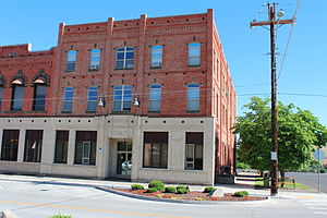
Asotin County | |
|---|---|
 Asotin County Courthouse | |
 Location within the U.S. state of Washington | |
 Washington's location within the U.S. | |
| Coordinates: 46°11′N 117°11′W / 46.18°N 117.19°W | |
| Country | |
| State | |
| Founded | October 27, 1883 |
| Named for | Asotin Creek |
| Seat | Asotin |
| Largest city | Clarkston |
| Area | |
• Total | 641 sq mi (1,660 km2) |
| • Land | 636 sq mi (1,650 km2) |
| • Water | 4.4 sq mi (11 km2) 0.7% |
| Population (2020) | |
• Total | 22,285 |
• Estimate (2023) | 22,549 |
| • Density | 35/sq mi (14/km2) |
| Time zone | UTC−8 (Pacific) |
| • Summer (DST) | UTC−7 (PDT) |
| Congressional district | 5th |
| Website | www |
Asotin County (/əˈsoʊtən/) is a county in the far southeastern corner of the U.S. state of Washington. As of the 2020 census, the population was 22,285.[1] The county seat is at Asotin,[2] and its largest city is Clarkston. The county was created out of Garfield County in 1883[3] and derives its name from a Nez Perce word meaning "Eel Creek." Asotin County is part of the Lewiston–Clarkston metropolitan area, which includes Nez Perce County, Idaho, and Asotin County.
- ^ "State & County QuickFacts". United States Census Bureau. Retrieved November 9, 2024.
- ^ "Find a County". National Association of Counties. Archived from the original on May 31, 2011. Retrieved June 7, 2011.
- ^ "Milestones for Washington State History — Part 2: 1851 to 1900". HistoryLink.org. March 6, 2003.