Assis | |
|---|---|
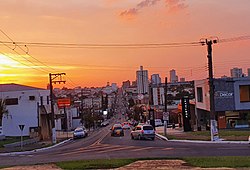
 Assis skyline at Rui Barbosa Avenue | |
 Location in São Paulo state | |
| Coordinates: 22°39′43″S 50°24′43″W / 22.66194°S 50.41194°W | |
| Country | Brazil |
| Region | Southeast |
| State | São Paulo |
| Mesoregion | Assis |
| Microregion | Assis |
| Government | |
| • Mayor | José Fernandes (PDT) (2017-2020) |
| Area | |
| • Total | 460.61 km2 (177.84 sq mi) |
| Elevation | 543 m (1,781 ft) |
| Population (2022)[2] | |
| • Total | 101,409 |
| • Density | 220/km2 (570/sq mi) |
| Time zone | UTC-03:00 (BRT) |
| • Summer (DST) | UTC-02:00 (BRST) |
| Postal code | 19800-000 |
| Area code | 18 |
| Website | www |
Assis is a city and a municipality in the southwestern part of the state of São Paulo in Brazil. The population is 101,409 (2022 est.) in an area of 460.61 km2.[2][3] The town was founded on July 5, 1905, and became a municipality in 1917, when it was separated from Platina.[4] It is the largest city of its microregion, and the 2nd of its mesoregion, and is 434 km away from the capital, São Paulo.[5] The town has an annual average temperature of 21,37 °C, annual rainfall 1,441 mm (56.7 in), and the vegetation predominates Mata Atlântica and Cerrado, is then a transition zone of vegetation. Its Human Development Index (HDI) is 0.805, considered high if compared to state and is in 28th place among Brazilian cities.[6]
| Year | Pop. | ±% |
|---|---|---|
| 1920 | 13,047 | — |
| 1934 | 18,169 | +39.3% |
| 1940 | 23,703 | +30.5% |
| 1950 | 32,959 | +39.0% |
| 1960 | 42,666 | +29.5% |
| 1970 | 57,220 | +34.1% |
| 1980 | 67,357 | +17.7% |
| 1991 | 85,391 | +26.8% |
| 1992 | 77,066 | −9.7% |
| 1993 | 78,425 | +1.8% |
| 1994 | 79,609 | +1.5% |
| 1995 | 80,765 | +1.5% |
| 1997 | 84,758 | +4.9% |
| 1998 | 86,133 | +1.6% |
| 1999 | 87,505 | +1.6% |
| 2000 | 87,251 | −0.3% |
| 2001 | 88,535 | +1.5% |
| 2002 | 89,657 | +1.3% |
| 2003 | 90,774 | +1.2% |
| 2004 | 93,118 | +2.6% |
| 2005 | 94,415 | +1.4% |
| 2006 | 95,703 | +1.4% |
| 2007 | 92,965 | −2.9% |
| 2008 | 97,725 | +5.1% |
| 2009 | 98,715 | +1.0% |
| 2010 | 95,144 | −3.6% |
| 2012 | 96,333 | +1.2% |
| 2013 | 100,204 | +4.0% |
| 2014 | 100,911 | +0.7% |
| 2015 | 101,597 | +0.7% |
| 2020 | 105,087 | +3.4% |
| [7][8][9] [10] | ||
The name Assis is a reference to Captain Assis, who explored the lands of the region. Is currently formed by the city of Assis, with its single district headquarters since Tarumã became a separate municipality in 1990.[11][12]
The city is known for its title Fraternal City and the undergraduate courses from UNESP at Assis, FEMA (Municipal Assis Educational Foundation) and Unip (Universidade Paulista - Paulista University). In the city, there are many industries, schools, universities, large agriculture production and strong commerce and services. The city is the seat of the Roman Catholic Diocese of Assis. Assis is one of the most important of region and has a privileged geographic location where there are different types of agriculture. Furthermore, the city is served by Marcelo Pires Halzhausen State Airport. Assis is cropped by the railroad old Estrada de Ferro Sorocabana and by numerous highways connecting the main cities of the region, the states of Mato Grosso do Sul and Paraná
Furthermore, the city is regional development reference, with influence in the cities of Assis's Microregion, a few municipalities in the Ourinhos's Microregion, Marília's Microregion and North of Paraná by his commerce, services, cultural services, sports, science and technology that make Assis that bears the title of Capital of Paranapanema, even with strong competition from larger centers such as Marilia, Presidente Prudente and Londrina.
- ^ Instituto Brasileiro de Geografia e Estatística
- ^ a b "Brazilian Institute of Geography and Statistics" (PDF). 2018. Retrieved 6 March 2019.
2018 Estimates of Population
- ^ "Assis". cidades.ibge.gov.br. Retrieved 2023-11-02.
- ^ "Cria o municipio de Assis, na comarca de Campos Novos do Paranapanema" (in Portuguese).
- ^ "Distâncias entre a cidade de São Paulo e todas as cidades do interior paulista".
- ^ "IDH brasileiro e posições por cidade" (in Portuguese).
- ^ Cf. BRASIL. Instituto Brasileiro de Geografia e Estatística (IBGE). Enciclopédia dos Município brasileiros. cit., vol XXVIII, 1956, págs. 87-88.
- ^ "Estimativa populacional de Assis para 2015" (PDF) (in Portuguese).
- ^ AssisCity. "IBGE estima população em 96333".
- ^ "Estimativas de 1992 até 2014".
- ^ "Dispõe sobre alterações no Quadro Territorial-Administrativo do Estado" (in Portuguese).
- ^ "História de Assis - Site da Câmara Municipal de Assis" (in Portuguese). Archived from the original on 2014-01-04.


