| Atacama Desert | |
|---|---|
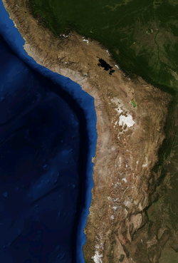
 Atacama by NASA World Wind | |
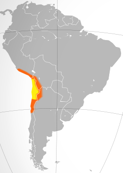
 Map of the Atacama Desert: the area most commonly defined as Atacama is in yellow. In orange are the outlying arid areas of the southern Chala, Altiplano, Puna de Atacama, and Norte Chico. The vertical extent of the satellite photo is approximately 2,600 km, encompassing the desert and surrounding regions. | |
| Ecology | |
| Realm | Neotropical |
| Biome | Deserts and xeric shrublands |
| Borders | |
| Geography | |
| Area | 104,741 km2 (40,441 sq mi) |
| Country | Chile |
| Coordinates | 24°30′S 69°15′W / 24.500°S 69.250°W |
| Conservation | |
| Protected | 3,385 km² (3%)[1] |
The Atacama Desert (Spanish: Desierto de Atacama) is a desert plateau located on the Pacific coast of South America, in the north of Chile. Stretching over a 1,600-kilometre-long (1,000-mile) strip of land west of the Andes Mountains, it covers an area of 105,000 km2 (41,000 sq mi),[2] which increases to 128,000 km2 (49,000 sq mi) if the barren lower slopes of the Andes are included.[3]
The Atacama Desert is the driest nonpolar desert in the world, and the second driest overall, behind some specific spots within the McMurdo Dry Valleys.[4][5][6][7] It is the only true desert to receive less precipitation than polar deserts, and the largest fog desert in the world. The area has been used as an experimentation site for Mars expedition simulations due to its similarities to the Martian environment.
The constant temperature inversion caused by the cool north-flowing Humboldt ocean current and the strong Pacific anticyclone contribute to the extreme aridity of the desert.[8] The most arid region of the Atacama Desert is situated between two mountain chains, the Andes and the Chilean Coast Range, which are high enough to prevent moisture advection from either the Pacific or the Atlantic Ocean, creating a two-sided rain shadow effect.[9]
- ^ Eric Dinerstein, David Olson, et al. (2017). An Ecoregion-Based Approach to Protecting Half the Terrestrial Realm, BioScience, Volume 67, Issue 6, June 2017, Pages 534–545; Supplemental material 2 table S1b. [1]
- ^ Wright, John W., ed. (2006). The New York Times Almanac (2007 ed.). New York: Penguin Books. pp. 456. ISBN 978-0-14-303820-7.
- ^ Rundel, P.W.; Villagra, P.E.; et al. (2007). "Arid and Semi-Arid Ecosystems". In Veblen, Thomas T.; Young, Kenneth R.; Orme, Anthony R. (eds.). Physical Geography of South America. Oxford University Press. pp. 158–183.
- ^ Clow GD, McKay CP, Simmons Jr GM, Wharton Jr RA (1988). "Climatological observations and predicted sublimation rates at Lake Hoare, Antarctica". Journal of Climate. 1 (7): 715–728. Bibcode:1988JCli....1..715C. doi:10.1175/1520-0442(1988)001<0715:COAPSR>2.0.CO;2. PMID 11538066.
- ^ Doran PT, McKay CP, Clow GD, Dana GL, Fountain AG, Nylen T, Lyons WB (2002). "Valley floor climate observations from the McMurdo Dry Valleys". Journal of Geophysical Research: Atmospheres. 107 (D24): ACL–13.
- ^ Porazinska DL, Fountain AG, Nylen TH, Tranter M, Virginia RA, Wall DH (2004). "The biodiversity and biogeochemistry of cryoconite holes from McMurdo Dry Valley glaciers, Antarctica". Arctic, Antarctic, and Alpine Research. 36 (1): 84–91. doi:10.1657/1523-0430(2004)036[0084:TBABOC]2.0.CO;2. ISSN 1523-0430. S2CID 35782175.
- ^ "Top 10 driest places on Earth". Our Planet. 9 November 2015.
- ^ Mckay, Christopher P. (2003). "Temperature and Moisture Conditions for Life in the Extreme Arid Region of the Atacama Desert: Four Years of Observations Including the El Niño of 1997–1998" (PDF). Astrobiology. 3 (2): 393–406. Bibcode:2003AsBio...3..393M. CiteSeerX 10.1.1.516.2293. doi:10.1089/153110703769016460. PMID 14577886.
- ^ Veblen, Thomas T., ed. (2007). The Physical Geography of South America. Oxford University Press. p. 160. ISBN 978-0-19-531341-3.