Atascadero, California | |
|---|---|
| City of Atascadero | |
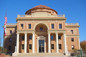
 Atascadero City Hall (Atascadero Colony Administration Building), built 1914–1918 | |
 Location of Atascadero in San Luis Obispo County, California | |
| Coordinates: 35°29′3″N 120°40′21″W / 35.48417°N 120.67250°W | |
| Country | United States |
| State | California |
| County | San Luis Obispo |
| Incorporated | July 2, 1979[1] |
| Founded by | Edward Gardner Lewis |
| Named for | Bog |
| Government | |
| • Type | Council–manager[2] |
| • Body | Atascadero City Council |
| • Mayor | Heather Moreno[3] |
| • City Manager | Jim Lewis[4] |
| • Council Members[3] | List |
| • Assemblymember | Dawn Addis (D)[5] |
| • State Senator | John Laird (D)[5] |
| Area | |
| • Total | 26.13 sq mi (67.69 km2) |
| • Land | 26.07 sq mi (67.52 km2) |
| • Water | 0.06 sq mi (0.16 km2) 1.87% |
| Elevation | 879 ft (268 m) |
| Population (2020) | |
| • Total | 29,773 |
| • Density | 1,142.04/sq mi (440.95/km2) |
| Time zone | UTC-8 (Pacific) |
| • Summer (DST) | UTC-7 (PDT) |
| ZIP codes | 93422–93423[8] |
| Area code | 805 |
| FIPS code | 06-03064 |
| GNIS feature IDs | 1660277, 2409745 |
| Website | www |

Atascadero (Spanish for "Mire") is a city in San Luis Obispo County, California, United States, located on U.S. Route 101. Atascadero is part of the San Luis Obispo-Paso Robles metropolitan statistical area, which encompasses the extents of the county. Atascadero is farther inland than most other cities in the county, and as a result, usually experiences warmer, drier summers, and cooler winters than other nearby cities such as San Luis Obispo and Pismo Beach. The main freeway through town is U.S. 101. The nearby State Routes 41 and 46 provide access to the Pacific Coast and the Central Valley of California.
Founded by E. G. Lewis in 1913, the city grew to 29,773 people as of 2020. Atascadero State Hospital is located in the city.
- ^ "California Cities by Incorporation Date". California Association of Local Agency Formation Commissions. Archived from the original (Word) on November 3, 2014. Retrieved August 25, 2014.
- ^ "City Council". City of Atascadero. Retrieved November 1, 2018.
- ^ a b "City Council Members". City of Atascadero. Retrieved November 1, 2018.
- ^ "City Manager Profile". City of Atascadero. Retrieved December 27, 2023.
- ^ a b "Statewide Database". UC Regents. Archived from the original on February 1, 2015. Retrieved November 18, 2014.
- ^ "2020 U.S. Gazetteer Files". United States Census Bureau. Retrieved October 30, 2021.
- ^ "Atascadero". Geographic Names Information System. United States Geological Survey, United States Department of the Interior. Retrieved October 22, 2014.
- ^ "ZIP Code(tm) Lookup". United States Postal Service. Retrieved November 7, 2014.


