Athol, Massachusetts | |
|---|---|
 Main Street | |
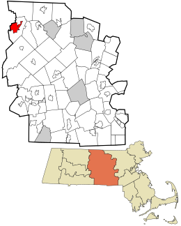
 Location in Worcester County and the state of Massachusetts. | |
| Coordinates: 42°35′31″N 72°13′49″W / 42.59194°N 72.23028°W | |
| Country | United States |
| State | Massachusetts |
| County | Worcester |
| Area | |
• Total | 8.47 sq mi (21.93 km2) |
| • Land | 8.19 sq mi (21.20 km2) |
| • Water | 0.28 sq mi (0.72 km2) |
| Elevation | 558 ft (170 m) |
| Population (2020) | |
• Total | 8,486 |
| • Density | 1,036.52/sq mi (400.21/km2) |
| Time zone | UTC-5 (Eastern (EST)) |
| • Summer (DST) | UTC-4 (EDT) |
| ZIP codes | 01331, 01368 |
| Area code | 978 |
| FIPS code | 25-02515 |
| GNIS feature ID | 0609627 |
Athol is a census-designated place (CDP) in the town of Athol in Worcester County, Massachusetts, United States. The population was 8,265 at the 2010 census.
- ^ "2020 U.S. Gazetteer Files". United States Census Bureau. Retrieved May 21, 2022.