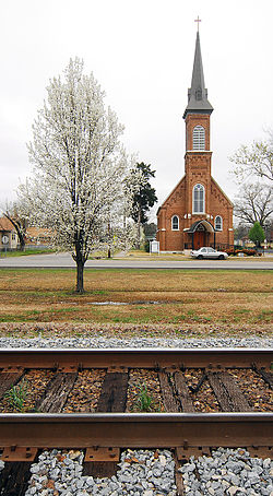
Atkins, Arkansas | |
|---|---|
City | |
 Atkins Roman Catholic Church of the Assumption | |
 Location of Atkins in Pope County, Arkansas. | |
| Coordinates: 35°14′37″N 92°56′18″W / 35.24361°N 92.93833°W | |
| Country | United States |
| State | Arkansas |
| County | Pope |
| Area | |
• Total | 6.14 sq mi (15.89 km2) |
| • Land | 6.13 sq mi (15.88 km2) |
| • Water | 0.01 sq mi (0.01 km2) |
| Elevation | 367 ft (112 m) |
| Population (2020) | |
• Total | 2,859 |
| • Density | 466.39/sq mi (180.09/km2) |
| Time zone | UTC−06:00 (Central (CST)) |
| • Summer (DST) | UTC−05:00 (CDT) |
| ZIP Code | 72823 |
| Area code | 479 |
| FIPS code | 05-02590 |
| GNIS feature ID | 2403125[2] |
Atkins is a city in Pope County, Arkansas, United States. The population was 3,016 at the 2010 census. It is part of the Russellville Micropolitan Statistical Area.
- ^ "2020 U.S. Gazetteer Files". United States Census Bureau. Retrieved October 29, 2021.
- ^ a b U.S. Geological Survey Geographic Names Information System: Atkins, Arkansas
