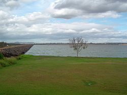
| Atkinson Dam | |
|---|---|
 Atkinson Dam wall | |
Location of the Atkinson Dam in Queensland | |
| Country | Australia |
| Location | South East Queensland |
| Coordinates | 27°25′42″S 152°26′39″E / 27.42833°S 152.44417°E |
| Purpose | Irrigation |
| Status | Operational |
| Opening date | 1970 |
| Operator(s) | SEQ Water |
| Dam and spillways | |
| Type of dam | Embankment dam |
| Impounds | Buaraba Creek |
| Height | 9 m (30 ft) |
| Length | 2,088 m (6,850 ft) |
| Dam volume | 74×103 m3 (2.6×10⁶ cu ft) |
| Spillways | One |
| Spillway type | Uncontrolled |
| Spillway capacity | 439 m3/s (15,500 cu ft/s) |
| Reservoir | |
| Creates | Lake Atkinson |
| Total capacity | 30,500 ML (1,080×106 cu ft)[1][2] |
| Catchment area | 32.72 km2 (12.63 sq mi) |
| Surface area | 556 ha (1,370 acres) |
| Maximum length | 4.2 km (2.6 mi) |
| Maximum width | 2.5 km (1.6 mi) |
| Maximum water depth | 9 m (30 ft) |
| Normal elevation | 65.7 m (216 ft) |
| Website www.seqwater.com.au | |
The Atkinson Dam is an earth-fill embankment dam across the Buaraba Creek and a naturally forming lagoon, which is located near Lowood in the South East region of Queensland, Australia. The main purpose of the dam is for irrigation of farming land in the lower Lockyer Valley. The resultant reservoir is called Lake Atkinson.
- ^ "Sunwater Current Water Storage Information". Archived from the original on 28 May 2010. Retrieved 18 February 2008.
- ^ "Atkinson Dam". Water supply: Dams & weirs. SEQ Water. Archived from the original on 25 May 2009. Retrieved 23 June 2014.
