Atlatlahucan | |
|---|---|
Town | |
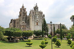
 The monastery of San Mateo Atlatahucan | |
| Country | |
| State | Morelos |
| Government | |
| • President | Alma Delia Reyes Linares[1] |
| Elevation | 1,617 m (5,305 ft) |
| Population (2020)[2] | |
| • Total | 25,232 |
| Time zone | UTC-6 (Central Zone) |
| • Summer (DST) | UTC-5 (Central Zone) |
| Postal code | 62840[3] |
| Area code | 735[1] |
Atlatlahucan /ˌætləˈtlaʊkæn/ (from the Nahuatl word [at͡ɬaˈt͡ɬaʍkan]) is a city in the Mexican state of Morelos. The name means Place of red or brown water, and today the water is stored in a type of cistern called a jagüey. To the north is the State of Mexico, south is Cuautla, east is Yecapixtla, and west are Tlayacapan and Yautepec.[4] It stands at 18°56′N 98°54′W / 18.933°N 98.900°W, at a mean height of 1,656 metres (5,433 ft.) above sea level. The municipality covers 71 km2 (27.4 square miles).
The city serves as the municipal seat for the surrounding municipality of the same name. The municipality reported 22,079 inhabitants in the 2015 census.[5] The population of the municipality of Atlatlahucan was 25,232 and the city of Atlatlahucan was 9,018 in 2020.[2]
- ^ a b c "Atlatlahucan en la region de Morelos - Municipio y ayuntamiento de México - ayuntamiento México - Información ayuntamiento, ciudades y pueblos de México". www.los-municipios.mx. Retrieved May 12, 2020.
- ^ a b Censo de Poblacion y Vivienda 2020
- ^ "Listado de todos los Códigos Postales de Atlatlahucan, Morelos". micodigopostal.org. Retrieved May 12, 2020.
- ^ "Estado de Morelos:Atlatlahucan" [State of Morelos:Atlatlahucan] (in Spanish). Enciclopedia de los Municipios y Delegaciones de Mexico. Retrieved Feb 5, 2019.
- ^ "INEGI Informacion de Mexico para niños" [Information about Mexico for children] (in Spanish). INEGI. Retrieved Feb 5, 2019.