Atna | |
|---|---|
Village | |
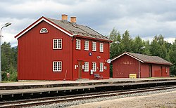
 View of the village railway station | |
| Coordinates: 61°43′51″N 10°49′55″E / 61.73078°N 10.83208°E | |
| Country | Norway |
| Region | Eastern Norway |
| County | Innlandet |
| District | Østerdalen |
| Municipality | Stor-Elvdal Municipality |
| Elevation | 356 m (1,168 ft) |
| Time zone | UTC+01:00 (CET) |
| • Summer (DST) | UTC+02:00 (CEST) |
| Post Code | 2476 Atna |
Atna is a village in Stor-Elvdal Municipality in Innlandet county, Norway. The village is located in the Østerdalen valley between Koppang and Alvdal at the confluence of the rivers Atna and Glomma.The Rørosbanen railway will stop at Atna Station by request. The Rondane mountains, Gudbrandsdal valley, and Ringebu are nearby.[2]

An airstrip is a few minutes away from the brewery. Although regular, commercial flights are unlikely, the 500-metre (1,600 ft) gravel strip is well maintained by skillful, voluntary villagers. It has seen an increasing amount of private traffic by culturally interested pilots. They seize the opportunity to refuel from the local pump and shop at the Coop. The local Glopheim Kafe is the only cafe in the country protected by the Directorate for Cultural Heritage. It is fully licensed and virtually unchanged since the early 1950s. The cafe serves guests with local specialties including the famous Atna beer. The closest place of accommodation is at Atna Camping which is a short walk from the centre of the village.
- ^ "Atna, Stor-Elvdal". yr.no. Retrieved 5 March 2022.
- ^ Thorsnæs, Geir, ed. (25 January 2022). "Atna (grend i Stor-Elvdal)". Store norske leksikon (in Norwegian). Kunnskapsforlaget. Retrieved 5 March 2022.

