| Auchendavy | |
|---|---|
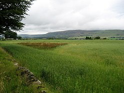
 View of the Campsie Fells from near Auchendavy Fort[1] | |
| Founded during the reign of | Antoninus Pius |
| Place in the Roman world | |
| Province | Britannia |
| Stationed military units | |
| — Legions — | |
| 20th 2nd | |
| Location | |
| Coordinates | 55°56′57″N 4°07′10″W / 55.94917°N 4.11944°W |
| County | East Dunbartonshire |
| Country | |
Auchendavy was a Roman fort on the Antonine Wall in Scotland.[2] Much of the site archeology was destroyed by the builders of the Forth and Clyde Canal.[3] Between Bar Hill and Balmuildy the wall roughly follows the southern bank of the River Kelvin.[4] The site of the fort is north of Kirkintilloch's northern border.[5] It can be seen as a mound mid-way between the Forth and Clyde Canal and the road.[6]
Sir George Macdonald wrote about the excavation of the site.[7] He says, "Auchendavy is distinguished for the large number of antiquities found in and about it." "About it" includes Shirva Farm in Twechar where finds such as several tombstones were found.
- ^ "near Auchendavy". OpenStreetMap. Retrieved 11 November 2017.
- ^ "Auchendavy; Antonine Wall". CANMORE. Royal Commission on the Ancient and Historical Monuments of Scotland. Retrieved 11 May 2010.
- ^ "Grim's Dyke - Destruction". Antoninewall.co.uk. Retrieved 11 November 2017.[permanent dead link]
- ^ Roy, William. "Map of the Scottish Lowlands". National Library for Scotland. Retrieved 26 October 2017.
- ^ "OS 25 inch map 1892-1949, with Bing opacity slider". National Library of Scotland. Ordnance Survey. Retrieved 12 October 2017.
- ^ "The Auchendavy Antonine Fort". Roman Britain. Archived from the original on 4 June 2018. Retrieved 11 November 2017.
- ^ Macdonald, Sir George (1934). The Roman wall in Scotland, by Sir George Macdonald (2d ed., rev., enl., and in great part rewritten ed.). Oxford: The Clarendon press. pp. 285–289. Retrieved 11 October 2017.