| Austinmer Wollongong, New South Wales | |||||||||||||||
|---|---|---|---|---|---|---|---|---|---|---|---|---|---|---|---|
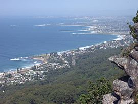
 Lookout from the Illawarra escarpment above Wombarra over the northern Illawarra plain viewing Austinmer in the foreground, Thirroul, Bulli, Wollongong up to Port Kembla in the far distance. | |||||||||||||||
| Coordinates | 34°18′23″S 150°56′04″E / 34.306311°S 150.93451°E | ||||||||||||||
| Population | 2,725 (2021 census)[1] | ||||||||||||||
| Postcode(s) | 2515 | ||||||||||||||
| Elevation | 27 m (89 ft) | ||||||||||||||
| Location |
| ||||||||||||||
| LGA(s) | City of Wollongong | ||||||||||||||
| State electorate(s) | Heathcote | ||||||||||||||
| Federal division(s) | Cunningham | ||||||||||||||
| |||||||||||||||
Austinmer (/ɔːstənmər/) is a northern village of Wollongong on the south coast of New South Wales, Australia. It sits in the northern Illawarra region, south of Stanwell Park and immediately north of Thirroul.
The town's main beach is Austinmer Beach, a patrolled surf beach and a popular tourist beach. A second smaller and unpatrolled beach lies directly to the north of Austinmer beach. It is called Little Austinmer Beach, known locally as 'dog beach', as it is a popular off-leash zone for dog walking.
The main road through the town is Lawrence Hargrave Drive, which connects with the Princes Highway at Bulli Pass. Moore Street connects Austinmer railway station to Lawrence Hargrave Drive, and, along with a short stretch along Lawrence Hargrave Drive, constitutes Austinmer's commercial presence, as well as a police station, school, churches, and veterinary clinic.
The Headland Hotel to the north of Austinmer Beach was featured in the 2005 to 2006 television series headLand.
It is served by Austinmer railway station on the South Coast railway line which runs electric double deck train services to Sydney and Wollongong.
- ^ Australian Bureau of Statistics (28 June 2022). "Austinmer (State Suburb)". 2021 Census QuickStats. Retrieved 20 July 2024.
