Aveyron
Avairon (Occitan) | |
|---|---|
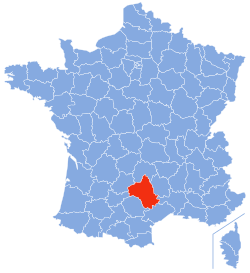
 Location of Aveyron in France | |
| Coordinates: 44°15′N 02°42′E / 44.250°N 2.700°E | |
| Country | France |
| Region | Occitania |
| Prefecture | Rodez |
| Subprefectures | Millau Villefranche-de-Rouergue |
| Government | |
| • President of the Departmental Council | Arnaud Viala[1] (UDI) |
| Area | |
• Total | 8,735 km2 (3,373 sq mi) |
| Population (2021)[2] | |
• Total | 279,649 |
| • Rank | 79th |
| • Density | 32/km2 (83/sq mi) |
| Time zone | UTC+1 (CET) |
| • Summer (DST) | UTC+2 (CEST) |
| Department number | 12 |
| Arrondissements | 3 |
| Cantons | 23 |
| Communes | 285 |
| ^1 French Land Register data, which exclude estuaries and lakes, ponds and glaciers larger than 1 km2 | |
Aveyron (French: [avɛʁɔ̃] ; Occitan: Avairon [aβajˈɾu]) is a department in the region of Occitania, Southern France. It was named after the river Aveyron. Its inhabitants are known as Aveyronnais (masculine) or Aveyronnaises (feminine) in French.[3] The inhabitants of Aveyron's prefecture, Rodez, are called Ruthénois, based upon the first settlers in the area, the Ruteni. With an area of 8,735 square kilometres (3,373 sq mi) and a population of 279,595, Aveyron is a largely rural department with a population density of 32 people/km2 (83 people/sq mi).[4]
- ^ "Répertoire national des élus: les conseillers départementaux". data.gouv.fr, Plateforme ouverte des données publiques françaises (in French). 4 May 2022.
- ^ "Téléchargement du fichier d'ensemble des populations légales en 2021" (in French). The National Institute of Statistics and Economic Studies. 28 December 2023.
- ^ "Le nom des habitants des communes de France - Habitants". www.habitants.fr.
- ^ Comparateur de territoires, INSEE


