| Avonlea Creek | |
|---|---|
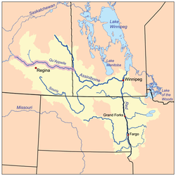
 The Red River drainage basin, with the Qu'Appelle River highlighted | |
| Location | |
| Country | Canada |
| Provinces | Saskatchewan |
| Physical characteristics | |
| Source | Piapot Cree First Nation 75G |
| • coordinates | 49°45′47″N 104°40′15″W / 49.76306°N 104.67083°W |
| • elevation | 640 m (2,100 ft) |
| Mouth | Moose Jaw River |
• location | 4 miles south-west of Rouleau |
• coordinates | 50°9′0″N 104°57′2″W / 50.15000°N 104.95056°W |
| Basin features | |
| River system | Red River |
Avonlea Creek[1] is a river in the southern part of the Canadian province of Saskatchewan. It is in a region called the Prairie Pothole Region of North America, which extends throughout three Canadian provinces and five U.S. states. It is also within Palliser's Triangle and the Great Plains ecoregion.[2] Avonlea Creek is a main tributary of the Moose Jaw River, which is part of the Upper Qu'Appelle Watershed[3] and the Hudson Bay drainage basin.
- ^ "Avonlea Creek". Canadian Geographical Names Database. Government of Canada. Retrieved 7 May 2022.
- ^ Bonikowsky, Laura (14 July 2013). "Drought in Palliser's Triangle". The Canadian Encyclopedia. Retrieved 13 March 2024.
- ^ "Our Watershed". WUQWATR. Retrieved 19 September 2021.

