Railway line in South Africa
| Avontuur Railway |
|---|
 Avontuur railway map |
|
|
|
|
|
|
|
0,0
|
Port Elizabeth
|
4 m
|
|
|
|
|
1,5
|
Humewood Road Actual terminal
|
21 m
|
|
|
|
|
4,4
|
Valley
|
|
|
|
|
|
Junction Walmer Branch (1906–1928)
|
|
|
|
|
7
|
Emerald Hill
|
|
|
|
|
|
Walmer (14th Avenue)
|
|
|
|
|
10
|
Bog Farm (Walmer Road)
|
|
|
|
|
14
|
Lorraine
|
150 m
|
|
|
|
|
17
|
Theescombe
|
|
|
|
|
|
N2 road crossing over line
|
|
|
|
|
22
|
Chelsea Junction EPPC Branch (1927–2001)
|
|
|
|
|
24
|
Greenbushes
|
|
|
|
|
27
|
Progress
|
|
|
|
|
30
|
St Albans
|
|
|
|
|
37
|
Geduldrivier
|
|
|
|
|
40
|
Witteklip
|
|
|
|
|
43
|
Van Stadens
|
249 m
|
|
|
|
|
44
|
Van Stadens Railway Bridge
|
|
|
|
|
47
|
Sunnyside
|
255 m
|
|
|
|
|
|
Bridge over N2
|
|
|
|
|
53
|
Thornhill
|
221 m
|
|
|
|
|
|
N2 road crossing over line
|
|
|
|
|
59
|
Summit
|
228 m
|
|
|
|
|
67
|
Kwaaibrand
|
|
|
|
|
72
|
Loerie Last station on the Apple Express
|
30 m
|
|
|
|
|
76
|
Melon
|
|
|
|
|
80
|
Gamtoos
|
7 m
|
|
|
|
|
|
Branch line to Patensie
|
|
|
|
|
81
|
Bridge over the Gamtoos River
|
|
|
|
|
83
|
Togo
|
|
|
|
|
85
|
Mondplaas
|
92 m
|
|
|
|
|
85
|
Bodker
|
|
|
|
|
|
N2 road crossing over line
|
|
|
|
|
|
Bridge over the Kabeljous River
|
|
|
|
|
90
|
Wagon Drift
|
|
|
|
|
92
|
Duplex
|
|
|
|
|
93
|
Kabeljousrivier
|
14 m
|
|
|
|
|
93
|
Hankey
|
22 m
|
|
|
|
|
100
|
Jeffreys Bay
|
100 m
|
|
|
|
|
104
|
Goonakop
|
|
|
|
|
104
|
The Burns
|
|
|
|
|
104
|
Patensie
|
55m
|
|
|
|
|
108
|
Drie Werve
|
|
|
|
|
113
|
Humansdorp
|
153 m
|
|
|
|
|
117
|
Kruisfontein
|
|
|
|
|
|
N2 road crossing over line
|
|
|
|
|
124
|
Kerkplaas
|
247 m
|
|
|
|
|
130
|
Billson
|
|
|
|
|
135
|
Howley
|
50 m
|
|
|
|
|
|
Bridge over the Dieprivier
|
|
|
|
|
|
R62 overpass
|
|
|
|
|
140
|
Salielaagte
|
204 m
|
|
|
|
|
146
|
Two Streams
|
280 m
|
|
|
|
|
153
|
Essenbos
|
|
|
|
|
161
|
Majoorskraal
|
189 m
|
|
|
|
|
164
|
Assegaaibos End of Regular operation
|
204 m
|
|
|
|
|
170
|
Melkhoutkraal
|
|
|
|
|
177
|
Jagersbos
|
|
|
|
|
183
|
Kammiebos
|
|
|
|
|
191
|
Kompanjiesdrif
|
|
|
|
|
201
|
Heights
|
533 m
|
|
|
|
|
209
|
Tweeriviere
|
|
|
|
|
214
|
Joubertina
|
544 m
|
|
|
|
|
215
|
Bridge over the Wabooms River
|
|
|
|
|
225
|
Krakeelrivier
|
|
|
|
|
232
|
Louterwater Last station during Citrus Season
|
659 m
|
|
|
|
|
235
|
|
|
|
|
|
238
|
Bruinklip
|
|
|
|
|
243
|
Nuweplaas
|
|
|
|
|
251
|
Misgund
|
|
|
|
|
256
|
Gaviota
|
|
|
|
|
261
|
Ongelegen
|
|
|
|
|
269
|
Haarlem
|
|
|
|
|
273
|
Siesta
|
|
|
|
|
285
|
Avontuur
|
871 m
|
|
|
|
|
|
|
|
|
| |
|
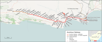
The Avontuur Railway is a closed railway line between Gqeberha and the town of Avontuur in the Western and Eastern Cape provinces of South Africa. It is the longest 610 mm (2 ft) narrow gauge route in the world at a length of 285 kilometres (177 mi).[1] "Avontuur" is the Afrikaans and Dutch word for "adventure".
- ^ Lewis, Charles; Pivnic, Les. "Soul of A Railway". System 3: Cape Midland, based in Port Elizabeth.
