Native name: 淡路島 Awaji-shima | |
|---|---|
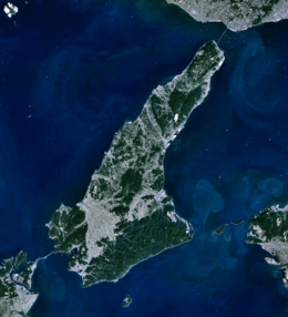
 Satellite view of Awaji Island | |
| Geography | |
| Location | Seto Inland Sea |
| Coordinates | 34°23′N 134°50′E / 34.383°N 134.833°E |
| Area | 592.17 km2 (228.64 sq mi) |
| Length | 53 km (32.9 mi) |
| Width | 28 km (17.4 mi) |
| Highest elevation | 606 m (1988 ft) |
| Administration | |
Japan | |
| Prefecture | Hyōgo Prefecture |
| Demographics | |
| Population | 129,000 (2019) |
| Pop. density | 265/km2 (686/sq mi) |
| Ethnic groups | Japanese |
Awaji Island (淡路島, Awaji-shima) is an island in Hyōgo Prefecture, Japan, in the eastern part of the Seto Inland Sea between the islands of Honshū and Shikoku. The island has an area of 592.17 square kilometres (228.64 square miles).[1] It is the largest island of the Seto Inland Sea.
As a transit between those two larger islands, Awaji originally means "the road to Awa",[2] the historic province bordering the Shikoku side of the Naruto Strait, now part of Tokushima Prefecture.
- ^ 本州の島面積 Archived 2008-12-29 at the Wayback Machine (Honshū no Shima Menseki) (Retrieved on July 4, 2009)
- ^ Martin Bermudez. "Geophysical and Seismic Analysis: Of Two Architectural Wonders". Geolabs-Hawaii Hillside Design Laboratory at the University of Hawaii School of Architecture. Archived from the original on 2008-05-28. Retrieved 2008-03-23.

