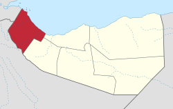
Awdal
| |
|---|---|
 Ruins of the Muslim Sultanate of Adal in Zeila | |
| Motto(s): | |
 Location in Somaliland | |
| Coordinates: 10°48′3″N 43°21′7″E / 10.80083°N 43.35194°E | |
| Country | |
| Administrative centre | Borama |
| Government | |
| • Type | Regional |
| • Governor | Hassan Dahir Haddi[1] |
| Area | |
| • Total | 21,374 km2 (8,253 sq mi) |
| Elevation | 2,136 m (7,008 ft) |
| Highest elevation | 2,632 m (8,635 ft) |
| Lowest elevation | 0 m (0 ft) |
| Population (2022[2]) | |
| • Total | 576,543 |
| • Density | 27/km2 (70/sq mi) |
| Time zone | UTC+3 (EAT) |
| Area code | +252 |
| ISO 3166 code | SO-AW |
| HDI (2021) | 0.401[3] low · 3rd |
Awdal (Somali: Awdal, Arabic: أودَل) is an administrative region (gobol)[4][5] in western Somaliland. It was separated from Woqooyi Galbeed and became a province in 1984 and is the most northwesterly province of Somaliland. To the east it borders Maroodi Jeex and Sahil; to its north-west it borders Djibouti; to its south and south-west lies Ethiopia; and the Gulf of Aden to its north.[6] The province has an estimated population of 1,010,566.[7] The region comprises the four districts of Borama, the regional capital, Baki, Lughaya, and Zeila.
- ^ "President Muse Bihi names new positions". 23 June 2023.
- ^ International Population Conference (IPC). "IPC Population Estimates: Projection (Apr-Jun 2023)" (PDF). Retrieved 16 December 2023.
- ^ "Sub-national HDI - Area Database - Global Data Lab". hdi.globaldatalab.org. Retrieved 13 September 2018.
- ^ "Somalia". The World Factbook. Langley, Virginia: Central Intelligence Agency.
- ^ "Awdal Region" (PDF). Archived (PDF) from the original on 3 December 2013. Retrieved 30 January 2014.
- ^ E. H. M. Clifford, "The British Somaliland-Ethiopia Boundary", Geographical Journal Archived 28 March 2017 at the Wayback Machine, Vol. 87, No. 4 (Apr. 1936), p. 296
- ^ "Population Estimation Survey 2014". Archived (PDF) from the original on 4 August 2017.