| Axial Seamount | |
|---|---|
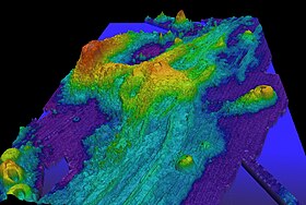
 Exaggerated swath bathymetry of Axial Seamount and the surrounding area.[n 1] | |
| Summit depth | 1,410 m (4,626 ft)[1] |
| Height | 1,100 m (3,609 ft)[1] |
| Location | |
| Location | Juan de Fuca Ridge |
| Coordinates | 46°04′N 130°00′W / 46.06°N 130°W |
| Geology | |
| Type | Seamount (Submarine volcano), Hotspot volcano, Shield volcano |
| Volcanic arc/chain | Cobb–Eickelberg Seamount chain |
| Last activity | April 2015 |
| Last eruption | April 2015 |
| History | |
| Discovery date | 1981[2] |
| Discovered by | NOAAS Surveyor[2] |
Axial Seamount (also Coaxial Seamount or Axial Volcano) is a seamount, submarine volcano, and underwater shield volcano[3] in the Pacific Ocean, located on the Juan de Fuca Ridge, approximately 480 km (298 mi) west of Cannon Beach, Oregon. Standing 1,100 m (3,609 ft) high,[4] Axial Seamount is the youngest volcano and current eruptive center of the Cobb–Eickelberg Seamount chain. Located at the center of both a geological hotspot and a mid-ocean ridge, the seamount is geologically complex, and its origins are still poorly understood. Axial Seamount is set on a long, low-lying plateau, with two large rift zones trending 50 km (31 mi) to the northeast and southwest of its center. The volcano features an unusual rectangular caldera, and its flanks are pockmarked by fissures, vents, sheet flows, and pit craters up to 100 m (328 ft) deep; its geology is further complicated by its intersection with several smaller seamounts surrounding it.
Axial Seamount was first detected in the 1970s by satellite altimetry, and mapped and explored by Pisces IV, DSV Alvin, and others through the 1980s. A large package of sensors was dropped on the seamount through 1992, and the New Millennium Observatory was established on its flanks in 1996. Axial Seamount received significant scientific attention following the seismic detection of a submarine eruption at the volcano in January 1998, the first time a submarine eruption had been detected and followed in situ. Subsequent cruises and analysis showed that the volcano had generated lava flows up to 13 m (43 ft) thick, and the total eruptive volume was found to be 18,000–76,000 km3 (4,300–18,200 cu mi). Axial Seamount erupted again in April 2011, producing a mile-wide lava flow. There was another eruption in 2015.
Cite error: There are <ref group=n> tags on this page, but the references will not show without a {{reflist|group=n}} template (see the help page).
- ^ a b "Axial Volcano". Vents program. National Oceanic and Atmospheric Administration/Pacific Marine Environmental Laboratory. Archived from the original on 28 May 2010. Retrieved 10 September 2010.
- ^ a b Cite error: The named reference
spot-axialwas invoked but never defined (see the help page). - ^ "Deep-sea volcano off the Oregon Coast helps scientists forecast eruptions".
- ^ "Axial Seamount". Global Volcanism Program. National Museum of Natural History. Archived from the original on 10 June 2010. Retrieved 10 September 2010.