Ayr, Nebraska | |
|---|---|
 Ayr, as seen from the west along Nebraska Highway 74, November 2012 | |
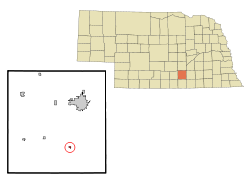
 Location of Ayr, Nebraska | |
| Coordinates: 40°26′16″N 98°26′27″W / 40.43778°N 98.44083°W | |
| Country | United States |
| State | Nebraska |
| County | Adams |
| Area | |
• Total | 0.24 sq mi (0.63 km2) |
| • Land | 0.24 sq mi (0.63 km2) |
| • Water | 0.00 sq mi (0.00 km2) |
| Elevation | 1,831 ft (558 m) |
| Population (2020) | |
• Total | 83 |
| • Density | 342.98/sq mi (132.27/km2) |
| Time zone | UTC-6 (Central (CST)) |
| • Summer (DST) | UTC-5 (CDT) |
| ZIP code | 68925 |
| Area code | 402 |
| FIPS code | 31-02865[3] |
| GNIS feature ID | 2398015[2] |
Ayr is a village in Adams County, Nebraska, United States. The population was 94 at the 2010 census. It is part of the Hastings, Nebraska Micropolitan Statistical Area.
- ^ "ArcGIS REST Services Directory". United States Census Bureau. Retrieved September 18, 2022.
- ^ a b U.S. Geological Survey Geographic Names Information System: Ayr, Nebraska
- ^ "U.S. Census website". United States Census Bureau. Retrieved January 31, 2008.