| Aztec Sandstone | |
|---|---|
| Stratigraphic range: Early Jurassic | |
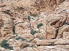
 Outcrop of the Aztec Sandstone at Red Rock Canyon National Conservation Area near Las Vegas, Nevada | |
| Type | Sedimentary |
| Underlies | Willow Tank Formation[1] |
| Overlies | Chinle Formation |
| Area | Nevada,[2] Arizona, California[3] |
| Thickness | 2,100 ft (640 m) in Goodsprings quadrangle[2] 2,500 ft (760 m) in Muddy Mountain area[1] |
| Lithology | |
| Primary | sandstone |
| Other | arenite, sand |
| Location | |
| Coordinates | 35°24′N 115°30′W / 35.4°N 115.5°W |
| Approximate paleocoordinates | 20°48′N 53°24′W / 20.8°N 53.4°W |
| Region | Mojave Desert |
| Country | |
| Type section | |
| Named by | D. F. Hewett[2] |
| Year defined | 1931 |
The Aztec Sandstone is an Early Jurassic geological formation of primarily eolian sand from which fossil pterosaur tracks have been recovered.[4] The formation is exposed in the Mojave Desert of Arizona, California and Nevada. Aztec Sandstone is named after the Aztec Tank,[5] a lake in the Spring Mountain region of Nevada.
- ^ a b Longwell, C.R. (1949). "Structure of the Northern Muddy Mountain Area, Nevada". Geological Society of America Bulletin. 60 (5): 923–968. Bibcode:1949GSAB...60..923L. doi:10.1130/0016-7606(1949)60[923:SOTNMM]2.0.CO;2. ISSN 0016-7606. Wikidata Q60182382.
- ^ a b c Hewett, D.F. (1931). "Geology and ore deposits of the Goodsprings quadrangle, Nevada" (PDF). Geological Survey Professional Paper (162). doi:10.3133/PP162. ISSN 0096-0446. Wikidata Q61823480. (incl. geologic map, scale 1:62,500)
- ^ Jennings, C.W., 1961, Geologic map of California; Kingman sheet: California Division of Mines and Geology, scale 1:250,000
- ^ Aztec Sandstone at Fossilworks.org
- ^ "Geolex — Aztec publications". ngmdb.usgs.gov. Retrieved 2023-03-14.

