Ba'kelalan | |
|---|---|
Town | |
| Other transcription(s) | |
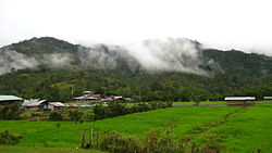
 Ba'kelalan paddy rice field | |
| Coordinates: 3°59′44″N 115°37′21″E / 3.99556°N 115.62250°E | |
| Country | |
| State | |
| Division | Limbang Division |
| District | Lawas District |
| Government | |
| • Penghulu | George Sigar Sultan[1] |
| Elevation | 910 m (2,990 ft) |
| Population (2003)[2] | |
• Total | 1,030 |
| Time zone | UTC+8 (MST) |
| • Summer (DST) | UTC+8 (Not observed) |
| Postal code | 98xxx |
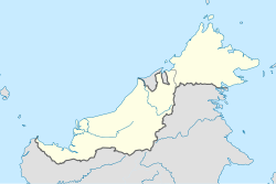
Ba'kelalan is a group of nine villages at Maligan Highlands of Limbang Division, Sarawak, Malaysia about 3,000 feet (910 m) above sea level and 4 km from the border with Indonesian Kalimantan and 150 km from the nearest town of Lawas.[3] There are nine villages in Ba'kelalan. The villagers here belong to the Lun Bawang tribe.
The name Ba’Kelalan is derived from the Kelalan River and Ba’ which means wet lands in the Lun Bawang language. Its population was about 1030 in 2003. In the cool mountain climate, temperate fruits such as apples, mandarin oranges and vanilla are grown. The area also produces rice, and mountain salt is obtained from the nearby hills. The people in Ba'Kelalan are Christian, members of the Sidang Injil Borneo.
Tourism has increased in recent years: Ba'kelalan now has a 9-hole natural golf course, and the settlement is also the easiest point of access for visits to Kayan Mentarang National Park in Krayan, Kalimantan.
- ^ Davidson, Desmond (1 May 2017). "Ba Kelalan villagers choke off trade route to punish Indonesians". The Malaysian Insight. Archived from the original on 18 September 2017. Retrieved 18 September 2017.
- ^ Cite error: The named reference
AmLwas invoked but never defined (see the help page). - ^ Cecilia, Sman (31 December 2013). "Ba Kelalan ready to flaunt its rich treasures for VMY 2014". The Borneo Post. Archived from the original on 1 July 2018. Retrieved 4 August 2019.
