This article includes a list of general references, but it lacks sufficient corresponding inline citations. (February 2014) |
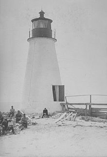
 Undated photograph of Back River Light, Virginia (USCG) | |
 | |
| Location | 1 nmi (1.9 km; 1.2 mi) south of the mouth of the Back River on the western shore of the Chesapeake Bay |
|---|---|
| Coordinates | 37°05′14″N 76°16′11″W / 37.0872°N 76.2698°W |
| Tower | |
| Construction | brick/masonry |
| Automated | 1915 |
| Height | 30 feet (9.1 m) |
| Shape | conical tower |
| Light | |
| First lit | 1829 |
| Deactivated | 1936 |
| Lens | Ten oil lamps and ten parabolic reflectors |
| Characteristic | continuous revolving white with a 90 second interval |
The Back River Light, also known as the Grandview Light, was a lighthouse south of the mouth of the Back River on the western shore of the Chesapeake Bay, several miles north of Fort Monroe near Hampton, Virginia. Plagued by erosion for most of its existence, it was destroyed in 1956 by Hurricane Flossy.
