Badrinath | |
|---|---|
Town | |
 | |
| Coordinates: 30°44′38″N 79°29′35″E / 30.744°N 79.493°E | |
| Country | |
| State | Uttarakhand |
| District | Chamoli |
| Area | |
• Total | 3 km2 (1 sq mi) |
| Elevation | 3,300 m (10,800 ft) |
| Population (2011)[1] | |
• Total | 2,438 |
| • Density | 810/km2 (2,100/sq mi) |
| Languages | |
| • Official | Hindi[2] |
| • Additional official | Sanskrit[3][4] |
| • Regional | Marchha, Garhwali |
| Time zone | UTC+5:30 (IST) |
| PIN | 246422[5] |
| Vehicle registration | UK 11 |
| Website | badrinath-kedarnath |
Char Dham
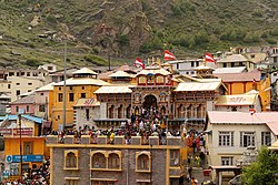
Badrinath is a town and nagar panchayat in Chamoli district in the state of Uttarakhand, India. It is a Hindu holy place, and is one of the four sites in India's Char Dham pilgrimage. It is also part of India's Chota Char Dham pilgrimage circuit and gets its name from the Badrinath Temple.
- ^ Cite error: The named reference
Census2011Govwas invoked but never defined (see the help page). - ^ "52nd Report of the Commissioner for Linguistic Minorities in India" (PDF). nclm.nic.in. Ministry of Minority Affairs. p. 47. Archived from the original (PDF) on 25 May 2017. Retrieved 16 January 2019.
- ^ Trivedi, Anupam (19 January 2010). "Sanskrit is second official language in Uttarakhand". Hindustan Times. Retrieved 5 January 2020.
- ^ "Sanskrit second official language of Uttarakhand". The Hindu. 21 January 2010. Retrieved 5 January 2020.
- ^ "Badrinath Pin code". pin-code.net. Archived from the original on 24 June 2021. Retrieved 18 June 2021.


