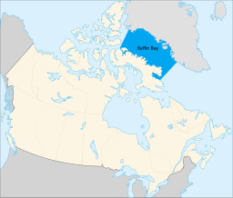
| Baffin Bay | |
|---|---|
 | |
| Location | Canada / Greenland |
| Coordinates | 74°N 68°W / 74°N 68°W[1] |
| Ocean/sea sources | Arctic Ocean |
| Basin countries | Canada and Greenland |
| Max. length | 1,450 km (900 mi) |
| Max. width | 110–650 km (68–404 mi) |
| Surface area | 689,000 km2 (266,000 sq mi) |
| Average depth | 861 m (2,825 ft) |
| Max. depth | 2,136 m (7,008 ft) |
| Water volume | 593,000 km3 (142,000 cu mi) |
| References | [2][3] |
Baffin Bay (Inuktitut: Saknirutiak Imanga;[4] Greenlandic: Avannaata Imaa;[5] French: Baie de Baffin;[6] Danish: Baffinbugten),[a] located between Baffin Island and the west coast of Greenland, is defined by the International Hydrographic Organization as a marginal sea of the Arctic Ocean.[8]: Art.23 It is sometimes considered a sea of the North Atlantic Ocean.[2][3][9] It is connected to the Atlantic via Davis Strait and the Labrador Sea. The narrower Nares Strait connects Baffin Bay with the Arctic Ocean. The bay is not navigable most of the year because of the ice cover and high density of floating ice and icebergs in the open areas. However, a polynya of about 80,000 km2 (31,000 sq mi), known as the North Water, opens in summer on the north near Smith Sound.[10] Most of the aquatic life of the bay is concentrated near that region.
- ^ "Baffin Bay". Geographical Names Data Base. Natural Resources Canada. 30 May 2024.
- ^ a b Baffin Bay Archived 13 May 2013 at the Wayback Machine, Great Soviet Encyclopedia (in Russian)
- ^ a b Baffin Bay, Encyclopædia Britannica on-line
- ^ Baffin Bay. Wissenladen.de. Retrieved on 2013-03-22.
- ^ "Den grønlandske Lods – Geodatastyrelsen" (PDF). Archived from the original (PDF) on 28 October 2020. Retrieved 7 May 2016.
- ^ "Baffin Bay". Geographical Names Data Base. Natural Resources Canada. 30 May 2024.
- ^ EB (1878).
- ^ "Limits of Oceans and Seas, 3rd edition" (PDF). International Hydrographic Organization. 1953. Retrieved 28 December 2020.
- ^ Reddy, M. P. M. (2001). Descriptive Physical Oceanography. Taylor & Francis. p. 8. ISBN 978-90-5410-706-4.
- ^ Circulation and generation of the North Water Polynya, Northern Baffin Bay. (PDF). Retrieved on 2013-03-22.
Cite error: There are <ref group=lower-alpha> tags or {{efn}} templates on this page, but the references will not show without a {{reflist|group=lower-alpha}} template or {{notelist}} template (see the help page).
