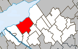
Baie-du-Febvre | |
|---|---|
 | |
 Location within Nicolet-Yamaska RCM | |
| Coordinates: 46°08′N 72°43′W / 46.13°N 72.72°W[1] | |
| Country | |
| Province | |
| Region | Centre-du-Québec |
| RCM | Nicolet-Yamaska |
| Constituted | March 26, 1983 |
| Government | |
| • Mayor | Claude Lefebvre |
| • Federal riding | Bas-Richelieu—Nicolet—Bécancour |
| • Prov. riding | Nicolet-Bécancour |
| Area | |
| • Total | 173.20 km2 (66.87 sq mi) |
| • Land | 96.78 km2 (37.37 sq mi) |
| Population | |
| • Total | 961 |
| • Density | 9.9/km2 (26/sq mi) |
| • Pop 2016-2021 | |
| • Dwellings | 517 |
| Time zone | UTC−5 (EST) |
| • Summer (DST) | UTC−4 (EDT) |
| Postal code(s) | |
| Area codes | 450 and 579 |
| Highways | |
| Website | www |
Baie-du-Febvre is a municipality in the Nicolet-Yamaska Regional County Municipality of Quebec, Canada. The population as of the Canada 2021 Census was 961. The municipality lies on the south shore of Lac Saint-Pierre, a section of the Saint Lawrence River.
- ^ Cite error: The named reference
toponymiewas invoked but never defined (see the help page). - ^ a b "Ministère des Affaires municipales, des Régions et de l'Occupation du territoire: Baie-du-Febvre". Archived from the original on 2012-05-01. Retrieved 2012-03-11.
- ^ "Parliament of Canada Federal Riding History: BAS-RICHELIEU--NICOLET--BÉCANCOUR (Quebec)". Archived from the original on 2009-06-09. Retrieved 2009-06-21.
- ^ a b "Tableau des données, Profil du recensement, Recensement de la population de 2021". 9 February 2022.
