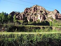
Bairi County
དཔའ་རིས་རྫོང་ · 天祝县 Tianzhu | |
|---|---|
| དཔའ་རིས་བོད་རང་སྐྱོང་རྫོང༌། · 天祝藏族自治县 Bairi Tibetan Autonomous County | |
 | |
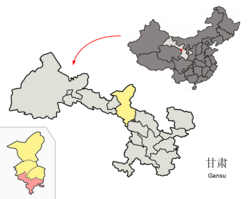
 Bairi County (red) within Wuwei City (yellow) and Gansu | |
| Coordinates: 36°58′18″N 103°08′31″E / 36.9718°N 103.1419°E | |
| Country | China |
| Province | Gansu |
| Prefecture-level city | Wuwei |
| County seat | Rabgyai (Huazangsi) |
| Area | |
| • Total | 7,149 km2 (2,760 sq mi) |
| Highest elevation | 4,874 m (15,991 ft) |
| Lowest elevation | 2,040 m (6,690 ft) |
| Population (2020)[1] | |
| • Total | 151,031 |
| • Density | 21/km2 (55/sq mi) |
| Time zone | UTC+8 (China Standard) |
| Postal code | 733200 |
| Website | www |
| Bairi Tibetan Autonomous County | |||||||
|---|---|---|---|---|---|---|---|
| Chinese name | |||||||
| Simplified Chinese | 天祝藏族自治县 | ||||||
| Traditional Chinese | 天祝藏族自治縣 | ||||||
| |||||||
| Alternative Chinese name | |||||||
| Simplified Chinese | 华锐 | ||||||
| Traditional Chinese | 華銳 | ||||||
| |||||||
| Tibetan name | |||||||
| Tibetan | དཔའ་རིས་བོད་རང་སྐྱོང་རྫོང༌། | ||||||
| |||||||
Bairi Tibetan Autonomous County (Tibetan: དཔའ་རིས་བོད་རང་སྐྱོང་རྫོང༌།), also known as Tianzhu from its Chinese name (Chinese: 天祝藏族自治县), is in the prefecture-level city of Wuwei in the central part of Gansu province, China, bordering Qinghai province to the south and west. It has an area of 7,147 km2 (2,759 sq mi) and approximately 230,000 inhabitants (2003). Its administrative seat is Rabgyai Town (Huazangsi).
- ^ "武威市第七次全国人口普查公报" (in Chinese). Government of Wuwei. 2021-05-27.

