| Disputed reef and islands | |
|---|---|
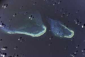
 Image of Bajo Nuevo from the ISS | |
| Other names | Petrel Islands |
| Geography | |
| Location | Caribbean Sea |
| Coordinates | 15°53′N 78°38′W / 15.883°N 78.633°W |
| Length | 26 km (16.2 mi) |
| Width | 9 km (5.6 mi) |
| Highest elevation | 2 m (7 ft) |
| Highest point | Unnamed location on Low Cay |
| Administration | |
| Department | San Andres and Providencia |
| Claimed by | |
| Demographics | |
| Population | 0 |
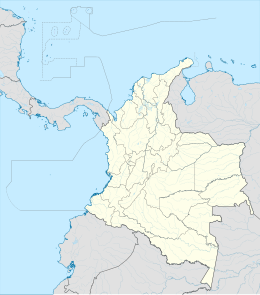
Bajo Nuevo Bank, also known as the Petrel Islands (Spanish: Bajo Nuevo, Islas Petrel), is a small, uninhabited reef with some small grass-covered islets, located in the western Caribbean Sea at 15°53′N 78°38′W / 15.883°N 78.633°W, with a lighthouse on Low Cay at 15°51′N 78°38′W / 15.850°N 78.633°W. The closest neighboring land feature is Serranilla Bank, located 110 kilometres (68 miles) to the west.
The reef was first shown on Dutch maps dating to 1634 but was given its present name in 1654. Bajo Nuevo was rediscovered by the English pirate John Glover in 1660. The reef is now subject to a sovereignty dispute involving Colombia and the United States. On 19 November 2012, regarding Nicaraguan claims to the islands, the International Court of Justice (ICJ) found, unanimously, that the Republic of Colombia has sovereignty over both Bajo Nuevo and Serranilla Banks, although the judgment does not analyze or mention the competing claims of Honduras or the United States.[1]
- ^ International Court of Justice (2012). "Territorial and maritime dispute (Nicaragua vs Colombia)" (PDF). Retrieved 27 November 2012.


