Bala | |
|---|---|
Compact rural community | |
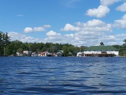
 The southern portion of the town as viewed from Bala Bay; the KEE to Bala is visible at right | |
| Etymology: Named for Bala, Wales | |
| Nickname: Cranberry Capital of Ontario[1] | |
| Coordinates: 45°01′03″N 79°37′02″W / 45.0175°N 79.6172°W[2] | |
| Country | Canada |
| Province | Ontario |
| District | Muskoka |
| Township Municipality | Muskoka Lakes |
| Established | 1868 |
| Incorporated (town) | 1914 |
| Amalgamated | 1971 |
| Founded by | Thomas Burgess |
| Elevation | 232 m (761 ft) |
| Time zone | UTC-5 (Eastern Time Zone) |
| • Summer (DST) | UTC-4 (Eastern Time Zone) |
| Postal code | P0C 1A0 |
| Area codes | 705, 249 |
Bala is a compact rural community[2] in the township municipality of Muskoka Lakes, District Municipality of Muskoka in Central Ontario, Canada.[2][4][5][6][7] It is well-known for the Bala Falls, the source of the Moon River, which flows from Lake Muskoka to the Georgian Bay.
It is considered one of the hubs of cottage country located north of Toronto. Thus, its year-round population of several hundred is increased by thousands of seasonal residents and weekend day-trippers during summer months. It is known as the Cranberry Capital of Ontario, as the province's largest cranberry farms, Muskoka Lakes Farm and Winery (formerly Johnston's Cranberry Marsh) and the former Iroquois Cranberry Growers (closed in 2017), are located nearby. It was once the smallest incorporated town in Canada until it was amalgamated into Muskoka Lakes Township.
- ^ "Welcome to the Cranberry Capital of Ontario". tvo.org.
- ^ a b c "Bala". Geographical Names Data Base. Natural Resources Canada. Retrieved 2018-08-09.
- ^ "mapcoordinates.net". Vivid Planet Software GmbH. Retrieved 2018-08-09.
- ^ "CLAIMaps IV". Ontario Ministry of Northern Development and Mines. 2016. Retrieved 2018-08-09.
- ^ "Toporama". Atlas of Canada. Natural Resources Canada. Retrieved 2018-08-09.
- ^ Map 5 (PDF) (Map). 1 : 700,000. Official road map of Ontario. Ministry of Transportation of Ontario. 2016-01-01. Retrieved 2018-08-10.
- ^ Restructured municipalities - Ontario map #4 (Map). Restructuring Maps of Ontario. Ontario Ministry of Municipal Affairs and Housing. 2006. Archived from the original on 2018-06-26. Retrieved 2018-08-10.
