Balao | |
|---|---|
Town | |
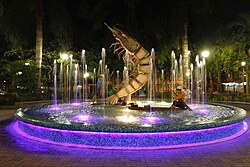
 Central park of Balao | |
| Motto(s): Por la Gloria y el Progreso de Balao (For the Glory and Progress of Balao) | |
| Coordinates: 2°54′38″S 79°49′00″W / 2.91047°S 79.81672°W | |
| Country | |
| Provinces | Guayas |
| Canton | Balao |
| Founded | before 1700 |
| Government | |
| • Mayor | Sandy Gómez |
| Area | |
| • Town | 1.34 km2 (0.52 sq mi) |
| Elevation | 10 m (30 ft) |
| Population (2022 census)[1] | |
| • Town | 12,850 |
| • Density | 9,600/km2 (25,000/sq mi) |
| Demonym | Balaoense |
| Time zone | UTC-5 (ECT) |
| Website | http://www.municipiodebalao.gob.ec/ |
Balao is a town located in southern Guayas, Ecuador, near Azuay and El Oro provinces. It is the seat of Balao Canton, created in 1987.
As of the census of 2022, Balao Canton had a population of 25,655.[2] The town is connected with Guayaquil and Machala. It has an airstrip.
The town and the canton take their name from a tree. An alternate theory for the name Balao comes from a tribe called Palau, who allegedly inhabited the area in pre-hispanic times.[3] The most important rivers are: the Balao River, the Jagua River, and the Gala River. The main crops are: banana, cacao, rice, maize, cassava, tomato, coffee, and tropical fruits.
- ^ Citypopulation.de Population and area of Balao
- ^ Citypopulation.de Population and area of Balao Canton
- ^ Cite error: The named reference
memoriawas invoked but never defined (see the help page).


