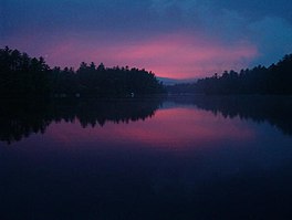
| Balch Pond | |
|---|---|
| Stump Pond | |
 | |
| Location | Carroll County, New Hampshire; York County, Maine |
| Coordinates | 43°36′58″N 70°58′39″W / 43.61611°N 70.97750°W |
| Type | Lake[1] |
| Primary outflows | Little Ossipee River |
| Catchment area | 14.3 square miles (37 km2) |
| Basin countries | United States |
| Max. length | 3.7 mi (6.0 km) |
| Max. width | 1.7 mi (2.7 km) |
| Surface area | 577 acres (2.34 km2) |
| Average depth | 10 ft (3.0 m) |
| Max. depth | 46 ft (14 m) |
| Water volume | 6,578 acre⋅ft (8,114,000 m3) |
| Residence time | 136 days |
| Shore length1 | 10.1 miles (16.3 km) |
| Surface elevation | 558 ft (170 m) |
| Settlements | Wakefield, New Hampshire; Acton and Newfield, Maine |
| 1 Shore length is not a well-defined measure. | |
Balch Pond [1] is a 577-acre (2.34 km2)[2] water body located on the New Hampshire-Maine border, in the towns of Wakefield, New Hampshire, and Acton and Newfield, Maine. A northwest portion of the lake in New Hampshire is known as Stump Pond.[3] Water flows from the eastern end of Balch Pond into the Little Ossipee River, a tributary of the Saco River.
The lake is classified as a warmwater fishery, with observed species including largemouth bass, chain pickerel, brown bullhead, black crappie, yellow perch, and sunfish.[2]
- ^ a b U.S. Geological Survey Geographic Names Information System: Balch Pond
- ^ a b "Balch Pond, Wakefield" (PDF). NH Fish & Game. Retrieved September 4, 2014.
- ^ U.S. Geological Survey Geographic Names Information System: Stump Pond


