| Baldersby | |
|---|---|
 Baldersby village | |
Location within North Yorkshire | |
| Population | 285 (2011 Census)[1] |
| OS grid reference | SE 355 785 |
| Unitary authority | |
| Region | |
| Country | England |
| Sovereign state | United Kingdom |
| Post town | THIRSK |
| Postcode district | YO7 |
| Police | North Yorkshire |
| Fire | North Yorkshire |
| Ambulance | Yorkshire |
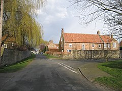
Baldersby is a village and civil parish in North Yorkshire, England, about 6 miles (10 km) west of Thirsk and 5 miles (8 km) north-east of Ripon on the A61. The parish includes the village of Baldersby St James, 1 mile (2 km) south-east of the village of Baldersby, but not Baldersby Park, which is in the parish of Rainton with Newby. According to the 2001 census the parish had a population of 253, increasing to 285 at the 2011 census.[1]
Baldersby has a farm shop, an Anglican Mission Room, and a cricket ground with a pavilion and children's play area. The nearest primary school is Baldersby St. James C of E Primary School in nearby Baldersby St James.
The Roman road Dere Street forms the western boundary of the parish, now followed by the A1(M) motorway. Baldersby Gate Interchange, Junction 50 of the A1(M), connects the A61 to the A1(M) in the south of the parish.
- ^ a b UK Census (2011). "Local Area Report – Baldersby Parish (E04007310)". Nomis. Office for National Statistics. Retrieved 5 February 2020.
