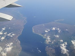
| Bali Strait | |
|---|---|
| Selat Bali (Indonesian) | |
 | |
| Coordinates | 8°18′S 114°25′E / 8.300°S 114.417°E |
| Type | strait |
| Basin countries | Indonesia |
| Max. length | 60 kilometers (37 mi) |
| Min. width | 2.4 kilometers (1.5 mi) |
| Average depth | 60 meters (200 ft) |
| References | Selat Bali: Indonesia National Geospatial-Intelligence Agency, Bethesda, MD, U.S. |
Bali Strait is a stretch of water separating Java and Bali while connecting the Indian Ocean and the Bali Sea. At its narrowest it is 2.4 kilometers (1.5 mi) wide.
