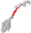
Ballangen Municipality
Ballangen kommune | |
|---|---|
 Nordland within Norway | |
 Ballangen within Nordland | |
| Coordinates: 68°18′23″N 16°44′39″E / 68.30639°N 16.74417°E | |
| Country | Norway |
| County | Nordland |
| District | Ofoten |
| Established | 1 July 1925 |
| • Preceded by | Evenes Municipality |
| Disestablished | 1 Jan 2020 |
| • Succeeded by | Narvik Municipality |
| Administrative centre | Ballangen |
| Government | |
| • Mayor (2015-2020) | Per Kristian Arntzen (Sp) |
| Area (upon dissolution) | |
• Total | 932.22 km2 (359.93 sq mi) |
| • Land | 846.38 km2 (326.79 sq mi) |
| • Water | 85.84 km2 (33.14 sq mi) 9.2% |
| • Rank | #119 in Norway |
| Highest elevation | 1,724 m (5,656 ft) |
| Population (2019) | |
• Total | 2,470 |
| • Rank | #292 in Norway |
| • Density | 2.6/km2 (7/sq mi) |
| • Change (10 years) | |
| Demonym | Ballangsværing[2][3] |
| Official language | |
| • Norwegian form | Bokmål |
| Time zone | UTC+01:00 (CET) |
| • Summer (DST) | UTC+02:00 (CEST) |
| ISO 3166 code | NO-1854[5] |
Ballangen (Northern Sami: Bálák) is a former municipality in Nordland county, Norway. The municipality existed from 1925 until its dissolution in 2020 when it became part of Narvik Municipality. The 932-square-kilometre (360 sq mi) municipality was part of the traditional district of Ofoten. The administrative centre of the municipality was the village of Ballangen. Other villages in the municipality included Bjørkåsen, Kjeldebotn, Kobbvika, and Skarstad.
Prior to its dissolution in 2020, the 932-square-kilometre (360 sq mi) municipality was the 119th largest by area out of the 422 municipalities in Norway. Ballangen was the 292nd most populous municipality in Norway with a population of 2,470. The municipality's population density was 2.6 inhabitants per square kilometre (6.7/sq mi) and its population had decreased by 5.8% over the previous 10-year period.[6][7]
The municipality bordered Narvik Municipality to the east and Tysfjord Municipality to the south, and had a short border with Sweden to the southeast. Ballangen was situated on the southern shore of Ofotfjorden. Ballangen also included the long and narrow Efjorden, just south of the much larger Ofotfjorden. Its immediate surroundings were dominated by fjords, mountains, and forests. Ballangen relied on the nearby town of Narvik as its economic base.
- ^ "Høgaste fjelltopp i kvar kommune" (in Norwegian). Kartverket. 16 January 2024. Archived from the original on 12 March 2019.
- ^ Andersen, Sander (9 March 2012). "Ballangsværing bak AWG-stadion". NRK (in Norwegian).
- ^ "Navn på steder og personer: Innbyggjarnamn" (in Norwegian). Språkrådet.
- ^ "Forskrift om målvedtak i kommunar og fylkeskommunar" (in Norwegian). Lovdata.no.
- ^ Bolstad, Erik; Thorsnæs, Geir, eds. (26 January 2023). "Kommunenummer". Store norske leksikon (in Norwegian). Kunnskapsforlaget.
- ^ Statistisk sentralbyrå. "Table: 06913: Population 1 January and population changes during the calendar year (M)" (in Norwegian).
- ^ Statistisk sentralbyrå. "09280: Area of land and fresh water (km²) (M)" (in Norwegian).

