Ballyhaunis
Béal Átha hAmhnais | |
|---|---|
Town | |
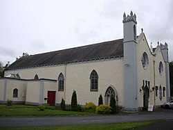
 Ballyhaunis Friary | |
| Coordinates: 53°46′00″N 8°46′00″W / 53.7667°N 8.7667°W | |
| Country | Ireland |
| Province | Connacht |
| County | County Mayo |
| Elevation | 89 m (292 ft) |
| Population | |
| • Total | 2,366 |
| Time zone | UTC+0 (WET) |
| • Summer (DST) | UTC+1 (IST (WEST)) |
| Irish Grid Reference | M498794 |
| Website | www |
Ballyhaunis (Irish: Béal Átha hAmhnais, meaning 'ford-mouth of strife')[2][3] is a town in County Mayo, Ireland. It is at the crossroads of the N60 and N83 National secondary roads and on the railway line linking Dublin to Westport and Ballina.
It is thought that the town grew up around St Mary's Augustinian Friary (popularly referred to as "the Abbey"), which was founded in 1348, according to local tradition. The town and its hinterland contain a number of megalithic monuments.[3]
According to the 2016 Census, Ballyhaunis had a population of 2,312. Non-Irish nationals made up 42% of the population,[4] which is much higher than the national average of and is the highest of any town in Ireland.[5] Poles and Pakistanis make up the largest groups of immigrants.[4] Meanwhile, ethnic Irish people make up 40% of the population.[6]
Ballyhaunis has one of the highest proportions of Muslims in Ireland. Around 23% of the town’s population of 2,300 identifies as Muslim as of the 2016 Census.[7]
There are two Roman Catholic churches in the town, and it is also home to Ireland's first purpose-built mosque, the first mosque in Ireland outside Dublin. Farming, private business and industry are the main sources of employment.[8]
Ballyhaunis is within both the Roman Catholic and civil parishes of Annagh.[9]
- ^ "Census 2016 Sapmap Area: Settlements Ballyhaunis". Central Statistics Office (Ireland). Archived from the original on 19 July 2018. Retrieved 19 July 2018.
- ^ "Placenames Database of Ireland". Logainm.ie (in Irish). Retrieved 7 August 2018.
- ^ a b "A Very Short History of Ballyhaunis and District" (PDF). Annagh Magazine. 2008. Archived from the original (PDF) on 7 September 2012. Retrieved 7 August 2018.
- ^ a b "2011 Census Results: Ballyhaunis Area" (PDF). CSO Census. 2011.
- ^ "The growth of intolerancee". The Irish Times. Dublin. 29 June 2013. ISSN 0791-5144.
- ^ "'Social cohesion' of Ballyhaunis 'under threat'". The Mayo News. 1 December 2015.
- ^ data.cso.ie https://data.cso.ie/. Retrieved 19 November 2023.
{{cite web}}: Missing or empty|title=(help) - ^ "Ballyhaunis Local Area Plan 2010-2016 accessed through Wayback Machine" (PDF). www.mayococo.ie. 8 February 2010. Archived from the original (PDF) on 16 November 2017. Retrieved 7 August 2018.
- ^ "Parish of Ballyhaunis". Archdiocese of Tuam. 10 December 2009. Archived from the original on 7 August 2018. Retrieved 7 August 2018.
