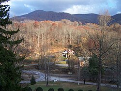
Balsam, North Carolina | |
|---|---|
 View from the Balsam Mountain Inn | |
| Coordinates: 35°25′36″N 83°05′07″W / 35.42680°N 83.08530°W | |
| Country | United States |
| State | North Carolina |
| County | Jackson |
| Incorporated | 1951 (inactive)[1] |
| Named for | Balsam Mountains |
| Area | |
| • Land | 3.2 sq mi (8 km2) |
| • Water | 0.0 sq mi (0 km2) |
| Elevation | 3,304 ft (1,007 m) |
| Population (2000) | |
| • Total | 49 |
| Time zone | UTC-5 (Eastern (EST)) |
| • Summer (DST) | UTC-4 (EDT) |
| ZIP code | 28707 |
| FIPS code | 828 |
| GNIS feature ID | 1018943[2] |
Balsam is an unincorporated community in Jackson County, North Carolina, United States. Named after the Balsam Mountains, it is home of the highest standard-gauge railroad east of the Rocky Mountains, at 3,315 feet (1,010 m).[1][3]
The community is located near Balsam Gap, a mountain pass between the Great Balsam Mountains and the Plott Balsams, two of the highest ranges in the Appalachian Mountains. The town and ranges are named after the nicknames of the red spruce and Fraser fir ("he-balsam" and "she-balsam," respectively), which are the dominant tree types at the highest elevations in the Southern Appalachian mountains.
- ^ a b "North Carolina Gazetteer". Retrieved March 6, 2023.
- ^ "Balsam". Geographic Names Information System. United States Geological Survey, United States Department of the Interior.
- ^ "US Gazetteer files: 2010, 2000, and 1990". United States Census Bureau. February 12, 2011. Retrieved April 23, 2011.

