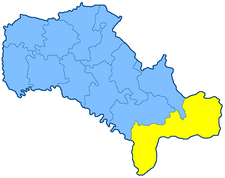
Balta uezd
Балтскій уѣздъ | |
|---|---|
 Location in the Podolia Governorate | |
| Country | Russian Empire |
| Krai | Southwestern |
| Governorate | Podolia |
| Established | 1796 |
| Abolished | 12 April 1923 |
| Capital | Balta |
| Area | |
| • Total | 7,766.25 km2 (2,998.57 sq mi) |
| Population (1897) | |
| • Total | 391,018 |
| • Density | 50/km2 (130/sq mi) |
| • Urban | 5.97% |
| • Rural | 94.03% |
The Balta uezd[a] was a county (uezd) of the Podolian Governorate of the Russian Empire. It bordered the Olgopol and Gaysin uezds to the north, the Uman uezd of the Kiev Governorate to the northeast, the Kherson Governorate's Elisavetgrad uezd to the east, and Ananev uezd to the south, and the Orgeev uezd of the Bessarabia Governorate to the west. Its administrative centre was Balta.
Cite error: There are <ref group=lower-alpha> tags or {{efn}} templates on this page, but the references will not show without a {{reflist|group=lower-alpha}} template or {{notelist}} template (see the help page).
