Ban Fang
บ้านฝาง | |
|---|---|
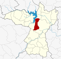
 District location in Khon Kaen province | |
| Coordinates: 16°27′12″N 102°38′18″E / 16.45333°N 102.63833°E | |
| Country | Thailand |
| Province | Khon Kaen |
| Seat | Ban Fang |
| Area | |
| • Total | 334.0 km2 (129.0 sq mi) |
| Population (2005) | |
| • Total | 52,999 |
| • Density | 158.7/km2 (411/sq mi) |
| Time zone | UTC+7 (ICT) |
| Postal code | 40270 |
| Geocode | 4002 |
Ban Fang (Thai: บ้านฝาง, pronounced [bâːn fǎːŋ]) is a district (amphoe) of Khon Kaen province, northeastern Thailand.