Ban Phai
บ้านไผ่ | |
|---|---|
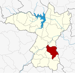
 District location in Khon Kaen province | |
| Coordinates: 16°3′36″N 102°43′51″E / 16.06000°N 102.73083°E | |
| Country | Thailand |
| Province | Khon Kaen |
| Area | |
• Total | 477.7 km2 (184.4 sq mi) |
| Population (2007) | |
• Total | 101,031 |
| • Density | 211.5/km2 (548/sq mi) |
| Time zone | UTC+7 (ICT) |
| Postal code | 40110 |
| Geocode | 4010 |
Ban Phai (Thai: บ้านไผ่, pronounced [bâːn pʰàj]; Northeastern Thai: บ้านไผ่, pronounced [bâːn pʰāj]) is a district (amphoe) of Khon Kaen province, northeastern Thailand.