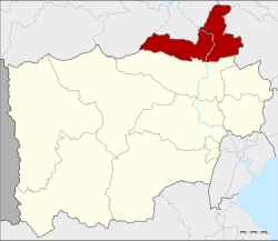
Ban Pong
บ้านโป่ง | |
|---|---|
 | |
 District location in Ratchaburi province | |
| Coordinates: 13°48′51″N 99°52′16″E / 13.81417°N 99.87111°E | |
| Country | Thailand |
| Province | Ratchaburi |
| Area | |
• Total | 366.6 km2 (141.5 sq mi) |
| Population (2017) | |
• Total | 172,752 |
| • Density | 471.22/km2 (1,220.5/sq mi) |
| Time zone | UTC+7 (ICT) |
| Postal code | 70110 |
| Geocode | 7005 |
Ban Pong (Thai: บ้านโป่ง, pronounced [bâːn pòːŋ]) is a district (amphoe) of Ratchaburi province, Thailand. It is in the northeast of the province.[1]
- ^ "Ban Pong". Mapcarta. Retrieved 8 October 2016.