Ban Sang
บ้านสร้าง | |
|---|---|
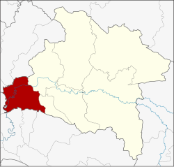
 District location in Prachinburi province | |
| Coordinates: 13°59′42″N 101°13′17″E / 13.99500°N 101.22139°E | |
| Country | Thailand |
| Province | Prachinburi |
| Area | |
| • Total | 361.2 km2 (139.5 sq mi) |
| Population (2005) | |
| • Total | 30,807 |
| • Density | 85.3/km2 (221/sq mi) |
| Time zone | UTC+7 (ICT) |
| Postal code | 25150 |
| Geocode | 2506 |
Ban Sang (Thai: บ้านสร้าง, pronounced [bâːn sâːŋ]) is the westernmost district (amphoe) of Prachinburi province, central Thailand.[1]